IMAGES TAKEN NEAR TO
Royston Road, GLASGOW, G21 2NU
Introduction
This page details the photographs taken nearby to Royston Road, G21 2NU by members of the Geograph project.
The Geograph project started in 2005 with the aim of publishing, organising and preserving representative images for every square kilometre of Great Britain, Ireland and the Isle of Man.

There are currently over 7.5m images from over14,400 individuals and you can help contribute to the project by visiting https://www.geograph.org.uk
Image Map
Images are licensed for reuse under creativecommons.org/licenses/by-sa/2.0
Notes
- Clicking on the map will re-center to the selected point.
- The higher the marker number, the further away the image location is from the centre of the postcode.
Image Listing (47 Images Found)
Images are licensed for reuse under creativecommons.org/licenses/by-sa/2.0
Image
Details
Distance
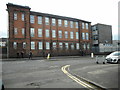
1
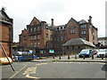
Royston Primary School
Built as St Rollox School, the building is Category B listed and dates from 1906.
Image: © Richard Sutcliffe
Taken: 23 Aug 2019
0.01 miles
2
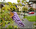
Painted lady
Feeding on a Buddleia bush beside Royston Road. Just one of many thousands of painted lady butterflies seen in Glasgow during July and August 2019, during a major migration of the species.
Image: © Richard Sutcliffe
Taken: 23 Aug 2019
0.04 miles
3
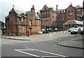
Royston Primary School
Built as St Rollox School, the building is Category B listed and dates from 1906.
Image: © Richard Sutcliffe
Taken: 23 Aug 2019
0.04 miles
4
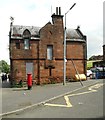
Royston Primary School
Former janitor's house. It is boarded up and there is vegetation growing on it in several places.
Image: © Richard Sutcliffe
Taken: 23 Aug 2019
0.04 miles
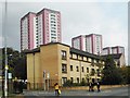
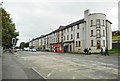
5
Royston Road
A mid-November view of this densely populated residential part of Glasgow city.
Image: © Mary and Angus Hogg
Taken: 22 Nov 2014
0.06 miles
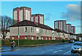
6
Flats on Royston Road
The tower blocks behind are on Charles Street.
Image: © Richard Sutcliffe
Taken: 23 Aug 2019
0.06 miles
8
St Roch's Secondary School
On Royston Road.
Image: © Richard Sutcliffe
Taken: 23 Aug 2019
0.10 miles
9
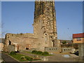
Townhead-Blochairn Church of Scotland, Roystonhill
Located on Roystonhill to the north of Glasgow city centre, the spire of this ruined church still dominates the skyline of the city, and has been illuminated at night since 1998. Built in 1865 for the Church of Scotland, it barely made its centenary before being closed due to low congregation numbers. It contained stained-glass windows by the world-famous William Morris company featuring beautiful designs by Glasgow artist Daniel Cottier. The church building itself was designed by Campbell Douglas and J.J. Stevenson. It was sold into private ownership in 1992 with the church building being used as a warehouse. Despite being an A-Listed protected structure, eventually the church building was demolished because of the neglect of the structure, but the spire - which was of considerable merit - was left untouched, and you can see the buttresses which still remains today. Interestingly, OS do not show the spire on their 1:50 or 1:25 mapping.
The area surrounding the spire was turned into a park and play area, however the area is gated and locked to prevent access when the nearby nursery on the same site closed. A website showing the development of the site is here; http://www.brocweb.com/spire/
Image: © Raymond Okonski
Taken: 16 Feb 2008
0.10 miles
10
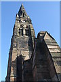
Roystonhill Spire
See description for Townhead-Blochairn Church of Scotland, Roystonhill
Image: © Raymond Okonski
Taken: 16 Feb 2008
0.10 miles