IMAGES TAKEN NEAR TO
Royston Road, GLASGOW, G21 2NF
Introduction
This page details the photographs taken nearby to Royston Road, G21 2NF by members of the Geograph project.
The Geograph project started in 2005 with the aim of publishing, organising and preserving representative images for every square kilometre of Great Britain, Ireland and the Isle of Man.

There are currently over 7.5m images from over14,400 individuals and you can help contribute to the project by visiting https://www.geograph.org.uk
Image Map
Images are licensed for reuse under creativecommons.org/licenses/by-sa/2.0
Notes
- Clicking on the map will re-center to the selected point.
- The higher the marker number, the further away the image location is from the centre of the postcode.
Image Listing (59 Images Found)
Images are licensed for reuse under creativecommons.org/licenses/by-sa/2.0
Image
Details
Distance
1
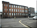
St Roch's Secondary School
On Royston Road.
Image: © Richard Sutcliffe
Taken: 23 Aug 2019
0.02 miles
2
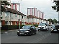
Royston Road
The tower blocks in the distance are on Charles Street.
Image: © Richard Sutcliffe
Taken: 23 Aug 2019
0.05 miles
3
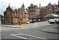
Royston Primary School
Built as St Rollox School, the building is Category B listed and dates from 1906.
Image: © Richard Sutcliffe
Taken: 23 Aug 2019
0.08 miles
4
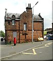
Royston Primary School
Former janitor's house. It is boarded up and there is vegetation growing on it in several places.
Image: © Richard Sutcliffe
Taken: 23 Aug 2019
0.08 miles
5
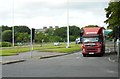
Road junction
A lorry waits at traffic lights about to turn onto Royston Road.
Image: © Richard Sutcliffe
Taken: 23 Aug 2019
0.09 miles
6
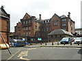
Royston Primary School
Built as St Rollox School, the building is Category B listed and dates from 1906.
Image: © Richard Sutcliffe
Taken: 23 Aug 2019
0.09 miles
7
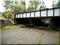
Pedestrian underpass
Now an underpass under the A803, Castle Street, this was originally a link between the Forth and Clyde and Monkland canals. A small section of the towpath survives. See Canmore https://canmore.org.uk/site/296804/glasgow-castle-street-bridge-underpass. The bridge once carried a tramway over the canal.
Image: © Richard Sutcliffe
Taken: 23 Aug 2019
0.11 miles
8
The Roystonhill Star
Viewed from the M8 motorway.
See Image for information about the star.
Image: © Thomas Nugent
Taken: 23 Feb 2020
0.12 miles
9
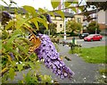
Painted lady
Feeding on a Buddleia bush beside Royston Road. Just one of many thousands of painted lady butterflies seen in Glasgow during July and August 2019, during a major migration of the species.
Image: © Richard Sutcliffe
Taken: 23 Aug 2019
0.12 miles
10
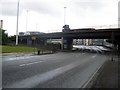
M8 slipway
Leads from Castle Street to the eastbound flow of the M8.
Image: © Stephen Sweeney
Taken: 19 Jun 2008
0.13 miles