IMAGES TAKEN NEAR TO
Royston Road, GLASGOW, G21 2BE
Introduction
This page details the photographs taken nearby to Royston Road, G21 2BE by members of the Geograph project.
The Geograph project started in 2005 with the aim of publishing, organising and preserving representative images for every square kilometre of Great Britain, Ireland and the Isle of Man.

There are currently over 7.5m images from over14,400 individuals and you can help contribute to the project by visiting https://www.geograph.org.uk
Image Map
Images are licensed for reuse under creativecommons.org/licenses/by-sa/2.0
Notes
- Clicking on the map will re-center to the selected point.
- The higher the marker number, the further away the image location is from the centre of the postcode.
Image Listing (14 Images Found)
Images are licensed for reuse under creativecommons.org/licenses/by-sa/2.0
Image
Details
Distance
2
Looking to Germiston highrise flats
From the walkway at junction 14 of the M8.
Image: © Stephen Sweeney
Taken: 21 Apr 2009
0.07 miles
3
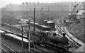
Garngad Sidings and site of station, with ex-NB 0-6-0 shunting
View southward from Royston Road, towards Bellgrove, ex-North British (former City of Glasgow Union) Bellgrove - Cowlairs Junction line, with Blochairn Road across the background. Garngad Station was closed in March 1910. The locomotive is one of the long-lasting NB Holmes J36 0-6-0's, No. 65246. Glasgow's East End, barely a blade of grass in sight.
Image: © Ben Brooksbank
Taken: 5 Oct 1961
0.07 miles
4
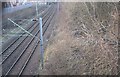
City of Glasgow Union Railway
The photograph was taken through a grille above a bridge parapet.
The railway is used by passenger services between Springburn and Balloch via Queen Street.
Image: © Richard Webb
Taken: 9 Apr 2013
0.07 miles
5
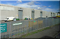
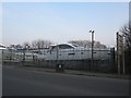
Blochairn Recycling Facility
A Glasgow City Council facility on Blochairn Road.
Image: © Thomas Nugent
Taken: 24 Aug 2022
0.10 miles
6
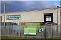
Glasgow Waste Transfer Station & Materials Recycling Facility
Image: © Leslie Barrie
Taken: 21 Nov 2013
0.11 miles
7
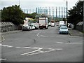
Blochairn Road
A Tesco lorry heads down the road towards the Category B listed gasholders at the site of the former Provan Gasworks. The gasholders are the largest ever built in Scotland. See http://portal.historicenvironment.scot/designation/LB52442 for a lot more information.
Image: © Richard Sutcliffe
Taken: 23 Aug 2019
0.13 miles
8
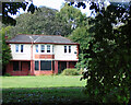
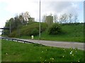
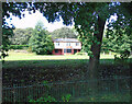
Glenconner Park bowling greens and pavilion
On Royston Road. Long disused and boarded-up, survives the attention of developers due to a condition of the original gifting of the park to the city by Lord Glenconner in 1915.
See also Image
Image: © Thomas Nugent
Taken: 24 Aug 2022
0.17 miles
9
Glenconner park bowling greens and pavilion
On Royston Road. Long disused and boarded-up, survives the attention of developers due to a condition of the original gifting of the park to the city by Lord Glenconner in 1915.
See also Image
Image: © Thomas Nugent
Taken: 24 Aug 2022
0.17 miles
10
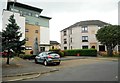
Properties at Cloverbank Gardens
Built by the Blochairn Housing Association in 1995. A large plaque above the entrance to the block on the right reads:
1 9
BHA
9 5
For a closer view of Andy Scott's sculpture on the left, see https://www.geograph.org.uk/photo/6249122.
Image: © Richard Sutcliffe
Taken: 23 Aug 2019
0.18 miles