IMAGES TAKEN NEAR TO
Lockhart Street, GLASGOW, G21 2AP
Introduction
This page details the photographs taken nearby to Lockhart Street, G21 2AP by members of the Geograph project.
The Geograph project started in 2005 with the aim of publishing, organising and preserving representative images for every square kilometre of Great Britain, Ireland and the Isle of Man.

There are currently over 7.5m images from over14,400 individuals and you can help contribute to the project by visiting https://www.geograph.org.uk
Image Map
Images are licensed for reuse under creativecommons.org/licenses/by-sa/2.0
Notes
- Clicking on the map will re-center to the selected point.
- The higher the marker number, the further away the image location is from the centre of the postcode.
Image Listing (4 Images Found)
Images are licensed for reuse under creativecommons.org/licenses/by-sa/2.0
Image
Details
Distance
1
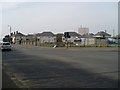
Germiston
Residential area in the north of Glasgow. Seen here from Royston Road.
Image: © Stephen Sweeney
Taken: 20 Apr 2009
0.11 miles
2
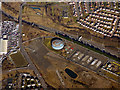
Provan gas works from the air
The northernmost of the three gas holders at the works, which are located by the M80 motorway which can also be seen.
Image: © Thomas Nugent
Taken: 19 Mar 2018
0.13 miles
3
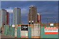
James McGrory Park, home of St Roch's FC, Glasgow
Founded 1921. Nickname 'The Candy Rock'
Image: © Leslie Barrie
Taken: 21 Nov 2013
0.19 miles
4

St Rochs Football Club
Junior side from Provanmill which spawned the Scottish league's most prolific scorer to date - Celtic's James McGrory.
Image: © Stephen Sweeney
Taken: 20 Apr 2009
0.25 miles