IMAGES TAKEN NEAR TO
Carleston Street, GLASGOW, G21 1TA
Introduction
This page details the photographs taken nearby to Carleston Street, G21 1TA by members of the Geograph project.
The Geograph project started in 2005 with the aim of publishing, organising and preserving representative images for every square kilometre of Great Britain, Ireland and the Isle of Man.

There are currently over 7.5m images from over14,400 individuals and you can help contribute to the project by visiting https://www.geograph.org.uk
Image Map
Images are licensed for reuse under creativecommons.org/licenses/by-sa/2.0
Notes
- Clicking on the map will re-center to the selected point.
- The higher the marker number, the further away the image location is from the centre of the postcode.
Image Listing (75 Images Found)
Images are licensed for reuse under creativecommons.org/licenses/by-sa/2.0
Image
Details
Distance
1
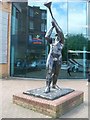
Statue outside Springburn Leisure Centre
On Springburn Way.
Image: © Stephen Sweeney
Taken: 27 May 2009
0.04 miles
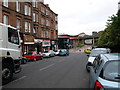
2
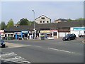
Springburn Way
Hillkirk Street is the road to the left.
Image: © Thomas Nugent
Taken: 28 Mar 2010
0.05 miles
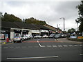
3
Springburn Way
Looking up the hill from the Atlas Road junction.
Image: © Thomas Nugent
Taken: 28 Mar 2010
0.08 miles
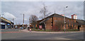
4
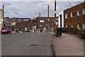
Shops on Springburn Way
Opposite the railway station.
Image: © Stephen Sweeney
Taken: 20 Apr 2009
0.08 miles
5
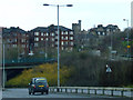
Springburn
From Springburn Road, just before passing under the Hawthorn Street flyover. Balgray Tower can be seen on the horizon.
Image: © Thomas Nugent
Taken: 5 Feb 2012
0.09 miles
6

Slip road off Springburn Road
Joining with Hawthorn Street.
Image: © Stephen Sweeney
Taken: 27 May 2009
0.10 miles
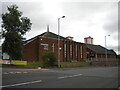
7
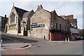
Springburn Parish Church
At the corner of Atlas Road and Springburn Way, opposite Springburn railway station.
Image: © Thomas Nugent
Taken: 28 Mar 2010
0.11 miles
8
South end of Springburn Way, Springburn
Off Atlas Road.
Image: © Richard Vince
Taken: 12 Sep 2022
0.11 miles
9
Springburn Parish Church, Atlas Road, Springburn
Image: © Richard Vince
Taken: 12 Sep 2022
0.12 miles
10
Springburn Road
Looking north along the revised alignment. Originally a main artery, the Springburn and Atlas Road bypasses made this former busy thoroughfare a quiet backwater by comparison.
Image: © Raymond Okonski
Taken: 12 Sep 2007
0.13 miles