IMAGES TAKEN NEAR TO
Memel Street, GLASGOW, G21 1LL
Introduction
This page details the photographs taken nearby to Memel Street, G21 1LL by members of the Geograph project.
The Geograph project started in 2005 with the aim of publishing, organising and preserving representative images for every square kilometre of Great Britain, Ireland and the Isle of Man.

There are currently over 7.5m images from over14,400 individuals and you can help contribute to the project by visiting https://www.geograph.org.uk
Image Map
Images are licensed for reuse under creativecommons.org/licenses/by-sa/2.0
Notes
- Clicking on the map will re-center to the selected point.
- The higher the marker number, the further away the image location is from the centre of the postcode.
Image Listing (30 Images Found)
Images are licensed for reuse under creativecommons.org/licenses/by-sa/2.0
Image
Details
Distance
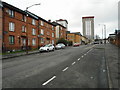
1
Fernbank Street
An entrance to Elmvale Primary School is on the left.
Image: © Richard Sutcliffe
Taken: 8 Mar 2017
0.08 miles
2
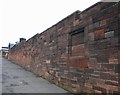
Playground wall, Elmvale Primary School
The playground walls (mainly red ashlar) together with the rest of the school and janitor's lodge, dating from 1901, are Category B listed.
Image: © Richard Sutcliffe
Taken: 8 Mar 2017
0.10 miles
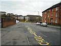
4
Fernbank Street
Looking towards Hawthorn Street.
Image: © Richard Sutcliffe
Taken: 8 Mar 2017
0.11 miles
5
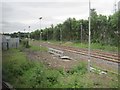
Cowlairs West railway Junction
View south towards Glasgow Queen Street just prior to electrification of the line. Because of the extensive engineering work, passenger trains were unusually being diverted onto the Springburn to Bishopbriggs line, from where the image was taken.
Image: © Nigel Thompson
Taken: 6 Jul 2016
0.12 miles
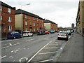
6
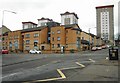
Flats on Hawthorn Street
The tower blocks behind are located between Carbisdale Street and Carron Street.
Image: © Richard Sutcliffe
Taken: 8 Mar 2017
0.13 miles
7
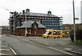
Elmvale Primary School and Janitor's Lodge
The Category B listed school is currently covered in scaffolding for renovation work.
Image: © Richard Sutcliffe
Taken: 8 Mar 2017
0.13 miles
8

The Salvation Army, Springburn
At the junction of Fernbank Street and Hawthorn Street.
Image: © Richard Sutcliffe
Taken: 8 Mar 2017
0.14 miles
9
The Salvation Army, Springburn
On Hawthorn Street.
Image: © Richard Sutcliffe
Taken: 8 Mar 2017
0.14 miles
10
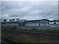
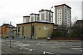
Network Rail building
At Cowlairs on the main line north out of Queen Street station.
Image: © Thomas Nugent
Taken: 11 Jul 2010
0.15 miles