IMAGES TAKEN NEAR TO
Endrick Street, GLASGOW, G21 1EH
Introduction
This page details the photographs taken nearby to Endrick Street, G21 1EH by members of the Geograph project.
The Geograph project started in 2005 with the aim of publishing, organising and preserving representative images for every square kilometre of Great Britain, Ireland and the Isle of Man.

There are currently over 7.5m images from over14,400 individuals and you can help contribute to the project by visiting https://www.geograph.org.uk
Image Map
Images are licensed for reuse under creativecommons.org/licenses/by-sa/2.0
Notes
- Clicking on the map will re-center to the selected point.
- The higher the marker number, the further away the image location is from the centre of the postcode.
Image Listing (32 Images Found)
Images are licensed for reuse under creativecommons.org/licenses/by-sa/2.0
Image
Details
Distance
1
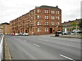
Tenements and bus shelter, Keppochhill Road
Endrick Street leads off to the right.
Image: © Richard Sutcliffe
Taken: 24 Jul 2020
0.07 miles
2
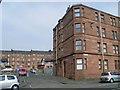
Traditional Glasgow tenements
On Keppochhill Road and Gourlay Street.
Image: © Stephen Sweeney
Taken: 20 Apr 2009
0.08 miles
3
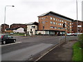
West of Scotland Housing Association Offices
The offices occupy the ground and 1st floor of the brick built flats in the picture. The picture is from the West on Keppochill Road, the road to the left is Carlisle Street. The Association has been active in the area since the 1970's. The low rise housing behind the offices was built along with the offices in 2003/4. The traditional Glasgow tenements are also owned and managed by the Association along with all the tenements going East along Keppochill Road to Springburn Road. 24th July 2009 9.30 a.m.
Image: © Gordon Dowie
Taken: 24 Jul 2009
0.09 miles
4
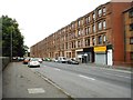
Tenements, Keppochhill Road
Red sandstone tenements and ground floor shops.
Image: © Richard Sutcliffe
Taken: 24 Jul 2020
0.09 miles
5
Old Gate Post, Carlisle Street, Springburn
Old gate post on corner of Carlisle Street and Inverurie Street Springburn. No idea what the history is of the post and would welcome further info from anyone who knows the area. The picture is looking North. The grassed area on the left was the site of Glasgow City Council flats demolished in the 90's. The area is now for sale. 24th July 2009 10.00 a.m.
Image: © Gordon Dowie
Taken: 24 Jul 2009
0.10 miles
6

Quarriers, Glasgow Regional Office
The building is on Keppochhill Road. It was previously occupied by the West of Scotland Housing Association. St Rollox Drive is in the foreground.
Quarriers is one of Scotland’s leading social care charities. They provide practical care and support for vulnerable children, adults and families who face extremely challenging circumstances.
Image: © Richard Sutcliffe
Taken: 24 Jul 2020
0.10 miles
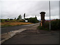
7
Railway line between Cowlairs and Glasgow
Looking towards Glasgow.
Image: © Nigel Thompson
Taken: 15 Jan 2020
0.10 miles
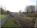
8

Next stop Glasgow Queen Street
Class 43, number 43125 heading towards Glasgow Queen Street (High Level) station. Seen from the Keppochhill Road bridge.
Image: © Richard Sutcliffe
Taken: 24 Jul 2020
0.11 miles
9
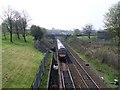
Train approaching Glasgow Queen Street
Seen from the Keppochhill Road bridge.
Image: © Stephen Sweeney
Taken: 20 Apr 2009
0.11 miles
10
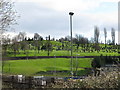
Rear view of Sighthill Cemetery
Sighthill Cemetery viewed from Keppochhill Road. The main entrance to Sighthill Cemetery is in the adjacent square; see Image
Image: © G Laird
Taken: 28 Mar 2009
0.13 miles