IMAGES TAKEN NEAR TO
Hazlitt Gardens, GLASGOW, G20 9LL
Introduction
This page details the photographs taken nearby to Hazlitt Gardens, G20 9LL by members of the Geograph project.
The Geograph project started in 2005 with the aim of publishing, organising and preserving representative images for every square kilometre of Great Britain, Ireland and the Isle of Man.

There are currently over 7.5m images from over14,400 individuals and you can help contribute to the project by visiting https://www.geograph.org.uk
Image Map
Images are licensed for reuse under creativecommons.org/licenses/by-sa/2.0
Notes
- Clicking on the map will re-center to the selected point.
- The higher the marker number, the further away the image location is from the centre of the postcode.
Image Listing (16 Images Found)
Images are licensed for reuse under creativecommons.org/licenses/by-sa/2.0
Image
Details
Distance
1
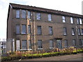
Hayston Street
Boarded-up Ruchill housing
Image: © Chris Upson
Taken: 6 Sep 2005
0.02 miles
4
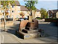
Surf City
The sandstone sculpture in the foreground is called "Surf City", and was created by Lucinda C. Wilkinson and Jamie R. W. Burroughs in 1999; in the same year, it was installed here, on the northern side of the main road (Bilsland Drive).
Image: © Lairich Rig
Taken: 11 Oct 2010
0.02 miles
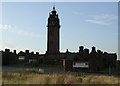
5
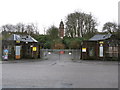
Entrance to the former Ruchill Hospital
Viewed from Bilsland Drive, the historic A-listed tower is still a dominant feature.
Image: © G Laird
Taken: 14 Mar 2009
0.09 miles
6
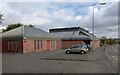
Ruchill Community Education Centre
The centre is located beside the junction of Bilsland Drive (visible on the right) and Parkside Gardens.
Image: © Lairich Rig
Taken: 1 Oct 2012
0.09 miles
7
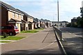
Bilsland Drive
The photograph shows some of the houses on the northern side of the road.
The land on the right-hand side (south) of the road had been associated with the Image (which closed in 1999).
Image: © Lairich Rig
Taken: 11 Oct 2010
0.12 miles
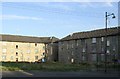
8
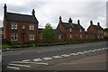
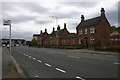
Houses, Bilsland Drive
Very distinctive red sandstone buildings on the southern side of Bilsland Drive.
Image: © Richard Sutcliffe
Taken: 14 Sep 2015
0.14 miles
10
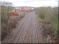
Possilpark railway station (site), Glasgow
Opened in 1885 on this North British Railway line from Glasgow Queen Street (High Level) towards Anniesland and the West Highland line, this station closed to passengers in 1917 but remained open for workmen only until 1964. It was demolished following closure.
View west towards Gilshochill and Anniesland. A new station called "Possilpark and Parkhouse" was opened immediately behind the camera position by British Rail in 1993 - see Image
Image: © Nigel Thompson
Taken: 15 Mar 2013
0.17 miles