IMAGES TAKEN NEAR TO
Smeaton Street, GLASGOW, G20 9LF
Introduction
This page details the photographs taken nearby to Smeaton Street, G20 9LF by members of the Geograph project.
The Geograph project started in 2005 with the aim of publishing, organising and preserving representative images for every square kilometre of Great Britain, Ireland and the Isle of Man.

There are currently over 7.5m images from over14,400 individuals and you can help contribute to the project by visiting https://www.geograph.org.uk
Image Map
Images are licensed for reuse under creativecommons.org/licenses/by-sa/2.0
Notes
- Clicking on the map will re-center to the selected point.
- The higher the marker number, the further away the image location is from the centre of the postcode.
Image Listing (6 Images Found)
Images are licensed for reuse under creativecommons.org/licenses/by-sa/2.0
Image
Details
Distance
1

Our Lady of the Assumption
This picture of the church (Roman Catholic) was taken from Bilsland Drive.
Image: © Lairich Rig
Taken: 1 Oct 2012
0.13 miles
2
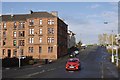
Mayfield Street
Junction with Ruchill Street.
Image: © Richard Webb
Taken: 30 Oct 2015
0.13 miles
4
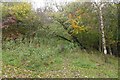
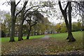
Little used path, Ruchill Park
Looks as if it was once quite wide.
Image: © Richard Webb
Taken: 30 Oct 2015
0.19 miles
5

Ruchill Community Education Centre
The centre is located beside the junction of Bilsland Drive (visible on the right) and Parkside Gardens.
Image: © Lairich Rig
Taken: 1 Oct 2012
0.21 miles