IMAGES TAKEN NEAR TO
Chapel Street Industrial Estate, GLASGOW, G20 9BQ
Introduction
This page details the photographs taken nearby to Chapel Street Industrial Estate, G20 9BQ by members of the Geograph project.
The Geograph project started in 2005 with the aim of publishing, organising and preserving representative images for every square kilometre of Great Britain, Ireland and the Isle of Man.

There are currently over 7.5m images from over14,400 individuals and you can help contribute to the project by visiting https://www.geograph.org.uk
Image Map
Images are licensed for reuse under creativecommons.org/licenses/by-sa/2.0
Notes
- Clicking on the map will re-center to the selected point.
- The higher the marker number, the further away the image location is from the centre of the postcode.
Image Listing (91 Images Found)
Images are licensed for reuse under creativecommons.org/licenses/by-sa/2.0
Image
Details
Distance
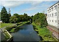
1
![Forth and Clyde Canal [26]](https://s0.geograph.org.uk/geophotos/06/24/92/6249248_56600f30_120x120.jpg)
Forth and Clyde Canal [26]
The traffic cones in the canal ensure that the fish keep in the correct lane.
The Forth and Clyde Canal was completed in 1790 and it provided a route for vessels between the Firth of Forth and the Firth of Clyde at the narrowest part (35 miles, 56km) of the Scottish Lowlands. Closed in 1963, the canal became semi-derelict. Millennium funds were used to regenerate the canal. The Glasgow Branch of the canal is a Scheduled Monument with details at: http://portal.historicenvironment.scot/designation/SM6771
Image: © Michael Dibb
Taken: 25 Jun 2019
0.02 miles
2
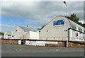
Industrial units, Chapel Street
Part of the Chapel Street Industrial Estate.
Image: © Richard Sutcliffe
Taken: 13 Sep 2021
0.03 miles
3
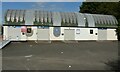
Industrial units, Chapel Street
The unit on the left is occupied by the Glasgow Access Panel (GAP), a registered charity (charity number SCO36531). Their aim is to improve the accessibility of services, buildings, facilities and information across Glasgow for all disabled people. See http://www.glasgowaccesspanel.org.uk/.
The adjoining unit is occupied by Two Player Print, a custom T-shirt store.
Image: © Richard Sutcliffe
Taken: 13 Sep 2021
0.03 miles
4
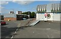
Junction of Ruchill Street and Chapel Street
Chapel Street is a small industrial estate with a variety of businesses based there.
Image: © Richard Sutcliffe
Taken: 13 Sep 2021
0.04 miles
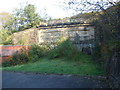
6
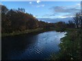
Forth and Clyde Canal
Seen from the Ruchill Street bridge. The building on the right was part of the Glasgow Lead and Colour Works.
Image: © Richard Sutcliffe
Taken: 13 Sep 2021
0.04 miles
7
Hidden Depths
Located directly behind a bingo hall in Maryhill is this rather imposing sandstone structure. Its reason for being there isn't apparent unless you check out the OS Map. This was part of the Glasgow Central Railway, that ran from Stobcross Junction to Maryhill Central via the Botanic Gardens.
Above is the Forth & Clyde canal, and the keystone of the railway tunnel can be seen behind the foliage. The tunnel's south portal has simply been stopped up with earth when the car park and bingo hall were built. The line was closed to passengers in 1959, and finally closed to freight in 1964. The tunnel mouth was eventually closed off in 1988.
Image: © Raymond Okonski
Taken: 23 Oct 2007
0.04 miles
8
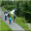
Geograph members enjoy a walk along the Forth and Clyde Canal
This was the afternoon before the 2019 AGM.
View from Ruchill Street bridge looking north.
Image: © Alan Murray-Rust
Taken: 25 Jun 2019
0.04 miles
9
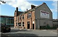
Framptons
Bar and nightclub at the corner of Maryhill Road and Ruchill Street.
Image: © Richard Sutcliffe
Taken: 13 Sep 2021
0.05 miles
10
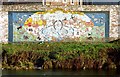
Glasgow canal mural
This picture is intended to complement Mark Nightingale's photograph: Image The present picture (a scan from 35mm film) is one that I took about seven years earlier, when the mural, which was created by schoolchildren in 1996, was better exposed to view.
The mural is on the north-eastern bank of the canal (Image), just to the north-west of Ruchill Bridge.
See Image for later changes.
Image: © Lairich Rig
Taken: Unknown
0.06 miles