IMAGES TAKEN NEAR TO
Maryhill Road, GLASGOW, G20 9AD
Introduction
This page details the photographs taken nearby to Maryhill Road, G20 9AD by members of the Geograph project.
The Geograph project started in 2005 with the aim of publishing, organising and preserving representative images for every square kilometre of Great Britain, Ireland and the Isle of Man.

There are currently over 7.5m images from over14,400 individuals and you can help contribute to the project by visiting https://www.geograph.org.uk
Image Map
Images are licensed for reuse under creativecommons.org/licenses/by-sa/2.0
Notes
- Clicking on the map will re-center to the selected point.
- The higher the marker number, the further away the image location is from the centre of the postcode.
Image Listing (120 Images Found)
Images are licensed for reuse under creativecommons.org/licenses/by-sa/2.0
Image
Details
Distance
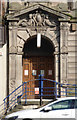
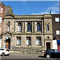
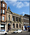
1
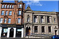
Maryhill Public Library, Maryhill Road, Glasgow
Category B-listed. Built 1903-1905. Architect James R Rhind.
Image: © Leslie Barrie
Taken: 29 Apr 2014
0.01 miles
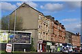
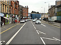
2
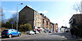
Maryhill Road
Looking down the hill from the aqueduct towards the library.
Image: © Thomas Nugent
Taken: 19 Mar 2016
0.01 miles