IMAGES TAKEN NEAR TO
Vasart Place, GLASGOW, G20 7SR
Introduction
This page details the photographs taken nearby to Vasart Place, G20 7SR by members of the Geograph project.
The Geograph project started in 2005 with the aim of publishing, organising and preserving representative images for every square kilometre of Great Britain, Ireland and the Isle of Man.

There are currently over 7.5m images from over14,400 individuals and you can help contribute to the project by visiting https://www.geograph.org.uk
Image Map
Images are licensed for reuse under creativecommons.org/licenses/by-sa/2.0
Notes
- Clicking on the map will re-center to the selected point.
- The higher the marker number, the further away the image location is from the centre of the postcode.
Image Listing (75 Images Found)
Images are licensed for reuse under creativecommons.org/licenses/by-sa/2.0
Image
Details
Distance
1
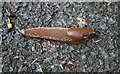
Arion slug
On a path in Ruchill Park.
Image: © Richard Sutcliffe
Taken: 22 Jul 2024
0.04 miles
3
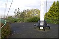
Flagpole, Ruchill Park
The park highpoint, on an artificial looking mound and at the end of a curved path.
Image: © Richard Webb
Taken: 30 Oct 2015
0.08 miles
4
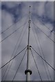
Flagpole, Ruchill Park
At the highest point in the park and surrounding area of Glasgow.
Image: © Richard Webb
Taken: 30 Oct 2015
0.08 miles
5
![Forth and Clyde Canal [23]](https://s0.geograph.org.uk/geophotos/06/24/84/6248404_a75f818d_120x120.jpg)
Forth and Clyde Canal [23]
A plate alongside the canal, giving the distances to Stockingfield Junction and Spiers Wharf.
Built in 1879, the aqueduct carries the canal over Bisland Road and is listed, category B, with details at: http://portal.historicenvironment.scot/designation/LB33745
The Forth and Clyde Canal was completed in 1790 and it provided a route for vessels between the Firth of Forth and the Firth of Clyde at the narrowest part (35 miles, 56km) of the Scottish Lowlands. Closed in 1963, the canal became semi-derelict. Millennium funds were used to regenerate the canal. The Glasgow Branch of the canal is a Scheduled Monument with details at: http://portal.historicenvironment.scot/designation/SM6771
Image: © Michael Dibb
Taken: 25 Jun 2019
0.08 miles
6
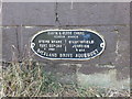
Canal Sign on Glasgow Branch of Forth and Clyde Canal on Bilsland Drive Aqueduct
Image: © Clive Nicholson
Taken: 10 Jul 2014
0.09 miles
7
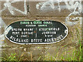
Milepost on Bilsland Drive aqueduct
The metal plate says it's 2 miles to Port Dundas (terminus of the Glasgow branch) and half a mile the other way to the junction at Stockinfield.
Image: © Stephen Craven
Taken: 25 Jun 2019
0.09 miles
8
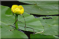
Yellow Water-lily (Nuphar lutea)
There are numerous patches of both Yellow and White Water-lily on the Glasgow Branch of the Forth and Clyde Canal, suggesting that the canal is little used by boats of any kind.
Image: © Anne Burgess
Taken: 25 Jun 2019
0.09 miles
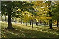
9
Main path
One of the main paths in Ruchill Park.
Image: © Richard Sutcliffe
Taken: 22 Jul 2024
0.09 miles
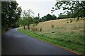
10
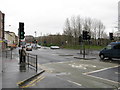
Maryhill Road
Looking south down Maryhill Road in the direction of Glasgow City Centre at the crossroads with Bilsland Drive and Queen Margaret Drive.
Image: © G Laird
Taken: 14 Mar 2009
0.10 miles