IMAGES TAKEN NEAR TO
Murano Street, GLASGOW, G20 7RX
Introduction
This page details the photographs taken nearby to Murano Street, G20 7RX by members of the Geograph project.
The Geograph project started in 2005 with the aim of publishing, organising and preserving representative images for every square kilometre of Great Britain, Ireland and the Isle of Man.

There are currently over 7.5m images from over14,400 individuals and you can help contribute to the project by visiting https://www.geograph.org.uk
Image Map
Images are licensed for reuse under creativecommons.org/licenses/by-sa/2.0
Notes
- Clicking on the map will re-center to the selected point.
- The higher the marker number, the further away the image location is from the centre of the postcode.
Image Listing (156 Images Found)
Images are licensed for reuse under creativecommons.org/licenses/by-sa/2.0
Image
Details
Distance
1
Murano Place
Viewed from the west end of Hill Street.
Image: © Thomas Nugent
Taken: 17 Jun 2013
0.04 miles
2
Ruchill Park
Looking towards Benview Street from the flagpole.
Image: © Richard Webb
Taken: 30 Oct 2015
0.05 miles
3
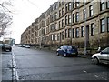
Murano Street, Firhill
Traditional style Glasgow street in the north of the city.
Image: © Stephen Sweeney
Taken: 20 Jan 2009
0.08 miles
4
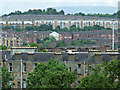
Forth and Clyde Canal
The Port Dundas Branch runs towards the city centre. There is a huge new residential block on the north/uphill side.
Image: © Richard Webb
Taken: 9 May 2012
0.09 miles
5

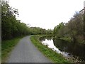
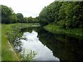
Forth & Clyde Canal (Glasgow Branch), Firhill
Although passing through an urban area, this canal is notable for the almost complete lack of industry lining its banks. It was very much a waterway designed for transit rather than giving access to premises. The result is a greenway that can seem surprisingly remote at times and can be explored from the well-maintained towpath.
Image: © Stephen McKay
Taken: 25 Jun 2019
0.09 miles
6
![Glasgow buildings [9]](https://s3.geograph.org.uk/geophotos/06/24/83/6248399_77885b8c_120x120.jpg)
Glasgow buildings [9]
Seen from the canal towpath are the 6 storey blocks flats of Murano Crescent.
Image: © Michael Dibb
Taken: 25 Jun 2019
0.10 miles
7
Forth and Clyde Canal, Maryhill
Difficult to appreciate that this is the heart of suburban Glasgow.
Image: © Alan Murray-Rust
Taken: 25 Jun 2019
0.10 miles
8
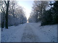
Snowy path in Ruchill Park
A path heading west from the southern entrance to Ruchill Park in unusually cold weather.
Image: © Mark Nightingale
Taken: 22 Dec 2010
0.10 miles
9
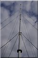
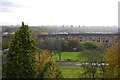
Flagpole, Ruchill Park
At the highest point in the park and surrounding area of Glasgow.
Image: © Richard Webb
Taken: 30 Oct 2015
0.10 miles
10
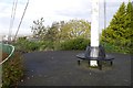
Flagpole, Ruchill Park
The park highpoint, on an artificial looking mound and at the end of a curved path.
Image: © Richard Webb
Taken: 30 Oct 2015
0.10 miles