IMAGES TAKEN NEAR TO
Murano Crescent, GLASGOW, G20 7RW
Introduction
This page details the photographs taken nearby to Murano Crescent, G20 7RW by members of the Geograph project.
The Geograph project started in 2005 with the aim of publishing, organising and preserving representative images for every square kilometre of Great Britain, Ireland and the Isle of Man.

There are currently over 7.5m images from over14,400 individuals and you can help contribute to the project by visiting https://www.geograph.org.uk
Image Map
Images are licensed for reuse under creativecommons.org/licenses/by-sa/2.0
Notes
- Clicking on the map will re-center to the selected point.
- The higher the marker number, the further away the image location is from the centre of the postcode.
Image Listing (198 Images Found)
Images are licensed for reuse under creativecommons.org/licenses/by-sa/2.0
Image
Details
Distance
1
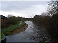
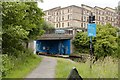
![Glasgow buildings [9]](https://s3.geograph.org.uk/geophotos/06/24/83/6248399_77885b8c_120x120.jpg)
Glasgow buildings [9]
Seen from the canal towpath are the 6 storey blocks flats of Murano Crescent.
Image: © Michael Dibb
Taken: 25 Jun 2019
0.00 miles
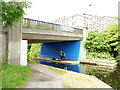
2
Canal in Firhill
From the bridge on Firhill Road.
Image: © Stephen Sweeney
Taken: 20 Jan 2009
0.03 miles
3
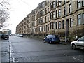
Murano Street, Firhill
Traditional style Glasgow street in the north of the city.
Image: © Stephen Sweeney
Taken: 20 Jan 2009
0.03 miles
4
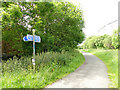
Cycle route sign by Firhill Road bridge
A path from Firhill Road joins the canal towpath here.
Image: © Stephen Craven
Taken: 25 Jun 2019
0.04 miles
5
Murano Place
Viewed from the west end of Hill Street.
Image: © Thomas Nugent
Taken: 17 Jun 2013
0.06 miles
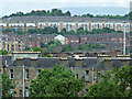
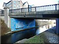
7
![Forth and Clyde Canal [20]](https://s0.geograph.org.uk/geophotos/06/24/83/6248396_ed1ecd43_120x120.jpg)
Forth and Clyde Canal [20]
Erected in 1991 to replace the former Firhill Bridge, this bridge carries Firhill Road over the canal. Firhill Bridge was originally a bascule bridge and then culverted. The plaque beneath the new bridge refers to it as Nolly Bridge.
The Forth and Clyde Canal was completed in 1790 and it provided a route for vessels between the Firth of Forth and the Firth of Clyde at the narrowest part (35 miles, 56km) of the Scottish Lowlands. Closed in 1963, the canal became semi-derelict. Millennium funds were used to regenerate the canal. The Glasgow Branch of the canal is a Scheduled Monument with details at: http://portal.historicenvironment.scot/designation/SM6771
Image: © Michael Dibb
Taken: 25 Jun 2019
0.06 miles
8
Firhill Road bridge
The workmen were just setting up for the day's work - Image was taken later the same day.
Image: © Stephen Craven
Taken: 25 Jun 2019
0.06 miles
9
The Nolly Brig
The bridge carries Firhill Road over the Forth and Clyde Canal.
Image: © Richard Sutcliffe
Taken: 8 Mar 2023
0.06 miles
10

Shamela's Cafe
On the corner of Firhill Road and Murano Street.
Image: © Richard Sutcliffe
Taken: 22 Jul 2024
0.06 miles