IMAGES TAKEN NEAR TO
Cedar Street, GLASGOW, G20 7PD
Introduction
This page details the photographs taken nearby to Cedar Street, G20 7PD by members of the Geograph project.
The Geograph project started in 2005 with the aim of publishing, organising and preserving representative images for every square kilometre of Great Britain, Ireland and the Isle of Man.

There are currently over 7.5m images from over14,400 individuals and you can help contribute to the project by visiting https://www.geograph.org.uk
Image Map
Images are licensed for reuse under creativecommons.org/licenses/by-sa/2.0
Notes
- Clicking on the map will re-center to the selected point.
- The higher the marker number, the further away the image location is from the centre of the postcode.
Image Listing (196 Images Found)
Images are licensed for reuse under creativecommons.org/licenses/by-sa/2.0
Image
Details
Distance
1
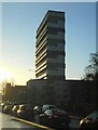
Tower block
Lorne Court seen from Garscube Road. The traffic is queuing for the traffic lights at St George's Road and Possil Road.
Image: © Richard Sutcliffe
Taken: 9 Dec 2022
0.02 miles
2
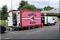
Sinéads Snacks
Snack trailer parked on Grovepark Street.
Image: © Richard Sutcliffe
Taken: 22 Jul 2024
0.02 miles
3
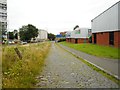
A former street
A former street beside Garscube Cross, now really just a wide path. In the 1890s it was called Society Row, but the name was later changed to Carnbroe Street. Today the cobbles remain, but the original buildings are gone. Garscube Road is in the distance. The modern buildings on the right (Prestige Car Specialists, and Graham the Plumbers' merchant) have access on the other side.
Image: © Richard Sutcliffe
Taken: 24 Jul 2020
0.03 miles
4
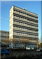
Tower block
Lorne Court, seen from beside Garscube Road.
Image: © Richard Sutcliffe
Taken: 9 Dec 2022
0.03 miles
5
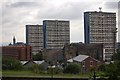
High rise flats
High rise flats at Garscube Road. The view is westwards, the tower of Glasgow University can be seen in the distance. Image
Image: © Paul McIlroy
Taken: 13 Jul 2007
0.04 miles
6
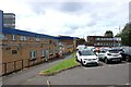
Barr Street Centre
Previously the Woodside Health Centre until a new facility Image was built.
Image: © Richard Sutcliffe
Taken: 22 Jul 2024
0.05 miles
7
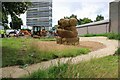
Construction work
Phase 1 of the Woodside Making Places project is under way.
Woodside Making Places is 'an ambitious vision that will transform Woodside, creating a vibrant and multi-functional green infrastructure network throughout the neighbourhood. It includes renewed pedestrian areas, cycling facilities and routes, biodiverse gardens and street trees, sustainable rainwater drainage, varied opportunities for play and leisure, and edible landscapes.' Funding is from Queens Cross Housing Association and Sustrans. [Information from project website]
Image: © Richard Sutcliffe
Taken: 22 Jul 2024
0.05 miles
8
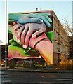
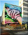
Hands mural, Garscube Road
On the end of a block of flats on St George's Road, facing onto Garscube Road. Painted by Rogue-one for the Queens Cross Housing Association, in conjunction with Artpistol projects in mid-2022.
Image: © Richard Sutcliffe
Taken: 9 Dec 2022
0.06 miles
9
Hands mural, Garscube Road
On the end of a block of flats on St George's Road, facing onto Garscube Road. Painted by Rogue-one for the Queens Cross Housing Association, in conjunction with Artpistol projects in mid-2022.
Image: © Richard Sutcliffe
Taken: 9 Dec 2022
0.06 miles
10
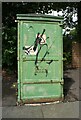
SSEB electricity cabinet
On Barr Street.
Image: © Richard Sutcliffe
Taken: 22 Jul 2024
0.06 miles