IMAGES TAKEN NEAR TO
McDonald Way, GLASGOW, G20 7AQ
Introduction
This page details the photographs taken nearby to McDonald Way, G20 7AQ by members of the Geograph project.
The Geograph project started in 2005 with the aim of publishing, organising and preserving representative images for every square kilometre of Great Britain, Ireland and the Isle of Man.

There are currently over 7.5m images from over14,400 individuals and you can help contribute to the project by visiting https://www.geograph.org.uk
Image Map
Images are licensed for reuse under creativecommons.org/licenses/by-sa/2.0
Notes
- Clicking on the map will re-center to the selected point.
- The higher the marker number, the further away the image location is from the centre of the postcode.
Image Listing (26 Images Found)
Images are licensed for reuse under creativecommons.org/licenses/by-sa/2.0
Image
Details
Distance
1
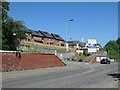
The Orchard, Panmure Street, Glasgow
A Keepmoat Homes' development of 2 and 3 bedroomed houses.
Image: © Christine Johnstone
Taken: 26 Jun 2019
0.07 miles
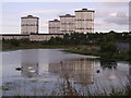
2

Towards Ruchill
Tower of the former Ruchill Hospital, taken from Firhill Basin
Image: © Lynn M Reid
Taken: 24 Mar 2008
0.10 miles
3
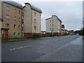
Modern flats on Panmure Road
In Possil Park.
Image: © Stephen Sweeney
Taken: 20 Jan 2009
0.10 miles
4
Development opportunity on Panmure Street, Glasgow
38.5 acres on the north side of the street have been allocated for residential use. This was the grounds of Ruchill Hospital.
Image: © Christine Johnstone
Taken: 26 Jun 2019
0.11 miles
5
Houses in Balglass Street, Glasgow
On the south side of Panmure and Stronend Streets.
Image: © Christine Johnstone
Taken: 26 Jun 2019
0.14 miles
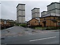
6
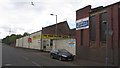
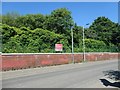
Stronend Road
Industrial buildings on the northside of Stronend Road.
Image: © Richard Webb
Taken: 9 May 2012
0.15 miles
7
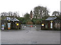
Entrance to the former Ruchill Hospital
Viewed from Bilsland Drive, the historic A-listed tower is still a dominant feature.
Image: © G Laird
Taken: 14 Mar 2009
0.17 miles
8
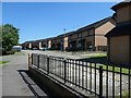
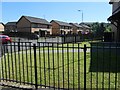
Houses on the south side of Stronend Street, Glasgow
Replacing an earlier housing estate in Possil Park.
Image: © Christine Johnstone
Taken: 26 Jun 2019
0.17 miles
10
Westercommon Road flats and new housing estate in Possil Park
From Stronend Street.
Image: © Stephen Sweeney
Taken: 20 Jan 2009
0.18 miles