IMAGES TAKEN NEAR TO
Kelvinside Avenue, GLASGOW, G20 6LU
Introduction
This page details the photographs taken nearby to Kelvinside Avenue, G20 6LU by members of the Geograph project.
The Geograph project started in 2005 with the aim of publishing, organising and preserving representative images for every square kilometre of Great Britain, Ireland and the Isle of Man.

There are currently over 7.5m images from over14,400 individuals and you can help contribute to the project by visiting https://www.geograph.org.uk
Image Map
Images are licensed for reuse under creativecommons.org/licenses/by-sa/2.0
Notes
- Clicking on the map will re-center to the selected point.
- The higher the marker number, the further away the image location is from the centre of the postcode.
Image Listing (58 Images Found)
Images are licensed for reuse under creativecommons.org/licenses/by-sa/2.0
Image
Details
Distance
1
Outdoor seating area, Cafe Ibiza
A new outdoor extension to the Cafe Ibiza (previously The Botanics).
Image: © Richard Sutcliffe
Taken: 6 Aug 2024
0.04 miles
2
Cafe Ibiza
Known as the Strathmore Bar until 2018, when it became The Botanics bar and restaurant, it has been transformed into Cafe Ibiza, which opened in June 2024.
Image: © Richard Sutcliffe
Taken: 6 Aug 2024
0.05 miles
3
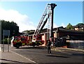
Platform truck
A fireman wipes down the platform of a platform truck outside Maryhill Fire Station.
Image: © Richard Sutcliffe
Taken: 6 Aug 2024
0.07 miles
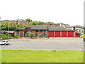
4
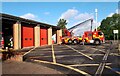
Maryhill Fire Station
With platform truck outside.
Image: © Richard Sutcliffe
Taken: 6 Aug 2024
0.07 miles
6
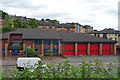
Maryhill Fire Station
The fire station is on Maryhill Road, and is viewed here from the canal towpath.
Image: © Anne Burgess
Taken: 25 Jun 2019
0.08 miles
7
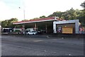
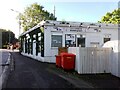
Esso filling station
On Maryhill Road.
Image: © Richard Sutcliffe
Taken: 6 Aug 2024
0.08 miles
8

Yellow Water-lily (Nuphar lutea)
There are numerous patches of both Yellow and White Water-lily on the Glasgow Branch of the Forth and Clyde Canal, suggesting that the canal is little used by boats of any kind.
Image: © Anne Burgess
Taken: 25 Jun 2019
0.09 miles
9
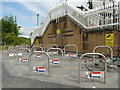
Maryhill Road cycle parking
The cycle racks are at the foot of the steps up to a bridge over the canal Image that leads to a student village, so students are obviously intended to leave their bikes here and walk over the bridge. Despite the CCTV warnings it doesn't look a secure location, and I expect many will carry their bikes up the steps and keep them in their flats.
Image: © Stephen Craven
Taken: 25 Jun 2019
0.09 miles
10
![Forth and Clyde Canal [21]](https://s0.geograph.org.uk/geophotos/06/24/84/6248400_ddfab0be_120x120.jpg)
Forth and Clyde Canal [21]
Maryhill Road footbridge links Maryhill Road to Caithness Street.
The Forth and Clyde Canal was completed in 1790 and it provided a route for vessels between the Firth of Forth and the Firth of Clyde at the narrowest part (35 miles, 56km) of the Scottish Lowlands. Closed in 1963, the canal became semi-derelict. Millennium funds were used to regenerate the canal. The Glasgow Branch of the canal is a Scheduled Monument with details at: http://portal.historicenvironment.scot/designation/SM6771
Image: © Michael Dibb
Taken: 25 Jun 2019
0.10 miles