IMAGES TAKEN NEAR TO
Garriochmill Way, GLASGOW, G20 6LL
Introduction
This page details the photographs taken nearby to Garriochmill Way, G20 6LL by members of the Geograph project.
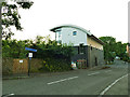
The Geograph project started in 2005 with the aim of publishing, organising and preserving representative images for every square kilometre of Great Britain, Ireland and the Isle of Man.

There are currently over 7.5m images from over14,400 individuals and you can help contribute to the project by visiting https://www.geograph.org.uk
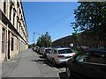
Image Map
Images are licensed for reuse under creativecommons.org/licenses/by-sa/2.0
Notes
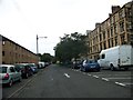
- Clicking on the map will re-center to the selected point.
- The higher the marker number, the further away the image location is from the centre of the postcode.
Image Listing (175 Images Found)
Images are licensed for reuse under creativecommons.org/licenses/by-sa/2.0
Image
Details
Distance
1
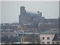
West End vista
Reminiscent of an Eastern European grain silo ( http://www.agrospol.cz/komodity.html ) the library building at Glasgow University dominates the scene. Viewed from the Forth and Clyde canal at Firhill.
Image: © Thomas Nugent
Taken: 13 Feb 2009
0.03 miles
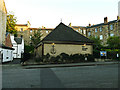
2

Former Boys Brigade hall, North Woodside Road
The listing for this building (Listed category B, LB32231) explains that it was built c.1879 as a Mission Hall, and in 1883 the Boys Brigade was founded here, giving it its historical significance. The BB and continued to meet in the building until 1973.
Image: © Stephen Craven
Taken: 26 Jun 2019
0.04 miles
3
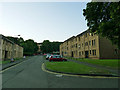
Garriochmill Road
Modern housing on the site of older housing.
Image: © Stephen Craven
Taken: 26 Jun 2019
0.05 miles
4
New Apostolic Church, North Woodside Road
An independent place of worship.
Image: © Stephen Craven
Taken: 26 Jun 2019
0.06 miles
5
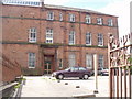
39 Napiershall St, Glasgow
This Glasgow City Council building used to be a primary school
Image: © G McK
Taken: 21 Jun 2005
0.08 miles
6
Raeberry Street, Glasgow, looking east
Older four-storey tenement flats on the north side, newer three-storey ones on the south side.
Image: © Christine Johnstone
Taken: 26 Jun 2019
0.08 miles
8
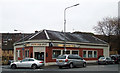
The Pewter Pot
A pub on North Woodside Road at South Woodside Road.
Image: © Thomas Nugent
Taken: 8 Dec 2012
0.09 miles
9
South Woodside Road
The modern building on the left overlooks the river Kelvin.
Image: © Stephen Craven
Taken: 26 Jun 2019
0.09 miles
10
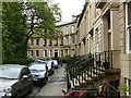
Lansdowne Crescent
Terraces of 2 and 3 storey houses from c.1852, Listed Category B as a group http://portal.historicenvironment.scot/designation/LB32215
Image: © Alan Murray-Rust
Taken: 24 Jun 2019
0.10 miles