IMAGES TAKEN NEAR TO
Holyrood Crescent, GLASGOW, G20 6HJ
Introduction
This page details the photographs taken nearby to Holyrood Crescent, G20 6HJ by members of the Geograph project.
The Geograph project started in 2005 with the aim of publishing, organising and preserving representative images for every square kilometre of Great Britain, Ireland and the Isle of Man.

There are currently over 7.5m images from over14,400 individuals and you can help contribute to the project by visiting https://www.geograph.org.uk
Image Map
Images are licensed for reuse under creativecommons.org/licenses/by-sa/2.0
Notes
- Clicking on the map will re-center to the selected point.
- The higher the marker number, the further away the image location is from the centre of the postcode.
Image Listing (235 Images Found)
Images are licensed for reuse under creativecommons.org/licenses/by-sa/2.0
Image
Details
Distance
1
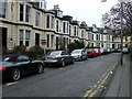
Holyrood Crescent
Near Great Western Road.
Image: © Thomas Nugent
Taken: 8 Dec 2012
0.01 miles
2
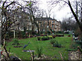
Garden at Holyrood Crescent
Between Holyrood Quadrant and Holyrood Crescent.
Image: © Thomas Nugent
Taken: 8 Dec 2012
0.03 miles
3
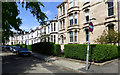
Holyrood Crescent
Off Napiershall Street.
Image: © Thomas Nugent
Taken: 17 May 2019
0.04 miles
4
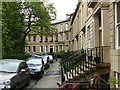
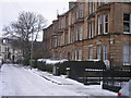
Lansdowne Crescent
Terraces of 2 and 3 storey houses from c.1852, Listed Category B as a group http://portal.historicenvironment.scot/designation/LB32215
Image: © Alan Murray-Rust
Taken: 24 Jun 2019
0.04 miles
5
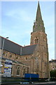
Cathedral church of St Mary the Virgin, Glasgow
Image: © Dave Kelly
Taken: 27 Aug 2001
0.05 miles
6
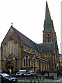
St Mary's Episcopal Cathedral
By English architect George Gilbert Scott http://en.wikipedia.org/wiki/George_Gilbert_Scott who was also responsible for the nearby Glasgow University as well as the Midland Grand Hotel at St Pancras Station, the Albert Memorial, and the Foreign and Commonwealth Office.
Image: © Thomas Nugent
Taken: 8 Dec 2012
0.05 miles
8
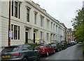
Lansdowne Crescent, Woodside, Glasgow ? west side
Terraced villas with attic and basement, c.1858; spearhead cast iron railings to steps and areas. Listed Category B http://portal.historicenvironment.scot/designation/LB32218
Image: © Alan Murray-Rust
Taken: 24 Jun 2019
0.07 miles
9
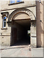
A pend on Napiershall Street
In a tenement on the west side of the street.
Image: © Thomas Nugent
Taken: 17 May 2019
0.07 miles
10
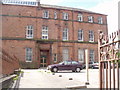
39 Napiershall St, Glasgow
This Glasgow City Council building used to be a primary school
Image: © G McK
Taken: 21 Jun 2005
0.07 miles