IMAGES TAKEN NEAR TO
Raeberry Street, GLASGOW, G20 6EG
Introduction
This page details the photographs taken nearby to Raeberry Street, G20 6EG by members of the Geograph project.
The Geograph project started in 2005 with the aim of publishing, organising and preserving representative images for every square kilometre of Great Britain, Ireland and the Isle of Man.

There are currently over 7.5m images from over14,400 individuals and you can help contribute to the project by visiting https://www.geograph.org.uk
Image Map
Images are licensed for reuse under creativecommons.org/licenses/by-sa/2.0
Notes
- Clicking on the map will re-center to the selected point.
- The higher the marker number, the further away the image location is from the centre of the postcode.
Image Listing (116 Images Found)
Images are licensed for reuse under creativecommons.org/licenses/by-sa/2.0
Image
Details
Distance
1
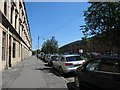
Raeberry Street, Glasgow, looking east
Older four-storey tenement flats on the north side, newer three-storey ones on the south side.
Image: © Christine Johnstone
Taken: 26 Jun 2019
0.02 miles
3
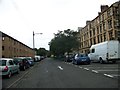
Housing at the junction of Kirkland and Wilton Streets, Glasgow
Part of a small estate bisected by Simpson Street.
Image: © Christine Johnstone
Taken: 26 Jun 2019
0.07 miles
4
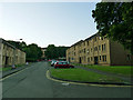
Garriochmill Road
Modern housing on the site of older housing.
Image: © Stephen Craven
Taken: 26 Jun 2019
0.08 miles
5
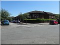
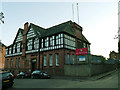
Army Reserve Centre, Jardine Street, Glasgow
Image: © Elliott Simpson
Taken: 4 Aug 2014
0.10 miles
6
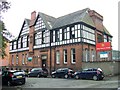
Army Reserve Centre, Garriochmill Road
This building dates from 1894 Image and is shown as a 'volunteer headquarters' on the 1896 map. see also Image Listed category B under its original identity as the Lanarkshire Regimental Drill Hall (LB32272) although the actual drill hall (behind this administrative building) has been demolished. It is currently home to the 52 (Lowland) Squadron of 32 Signal Regiment.
Image: © Stephen Craven
Taken: 26 Jun 2019
0.10 miles
7
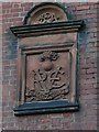
Army Reserve Centre, Garriochmill Road - detail
The inscription is 1894 REV Lanarkshire. See Image for context and history.
Image: © Stephen Craven
Taken: 26 Jun 2019
0.10 miles
8
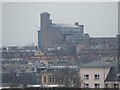
West End vista
Reminiscent of an Eastern European grain silo ( http://www.agrospol.cz/komodity.html ) the library building at Glasgow University dominates the scene. Viewed from the Forth and Clyde canal at Firhill.
Image: © Thomas Nugent
Taken: 13 Feb 2009
0.11 miles
9
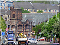
Maryhill Road
Looking towards Queens Cross and the Category A Listed 'Mackintosh Church' http://portal.historicenvironment.scot/designation/LB33764 .
Image: © Thomas Nugent
Taken: 17 May 2019
0.12 miles
