IMAGES TAKEN NEAR TO
Millhouse Drive, GLASGOW, G20 0UF
Introduction
This page details the photographs taken nearby to Millhouse Drive, G20 0UF by members of the Geograph project.
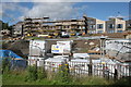
The Geograph project started in 2005 with the aim of publishing, organising and preserving representative images for every square kilometre of Great Britain, Ireland and the Isle of Man.

There are currently over 7.5m images from over14,400 individuals and you can help contribute to the project by visiting https://www.geograph.org.uk
Image Map
Images are licensed for reuse under creativecommons.org/licenses/by-sa/2.0
Notes
- Clicking on the map will re-center to the selected point.
- The higher the marker number, the further away the image location is from the centre of the postcode.
Image Listing (160 Images Found)
Images are licensed for reuse under creativecommons.org/licenses/by-sa/2.0
Image
Details
Distance
1
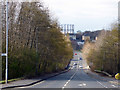
Cowal Road
Looking towards Kelvindale from Maryhill Road.
Image: © Thomas Nugent
Taken: 19 Mar 2016
0.04 miles
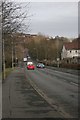
2
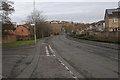
Cowal Road
Depending which map you look at, the main road here is either Cowal Road or Skaethorn Road. The road off to the left is Millhouse Drive.
Image: © Richard Sutcliffe
Taken: 24 Mar 2016
0.05 miles
3
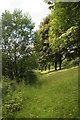
Trees beside the Kelvin
This is a strip of land between the River Kelvin on the left, and the Kelvin Walkway on the right.
Image: © Richard Sutcliffe
Taken: 8 Jul 2016
0.05 miles
4
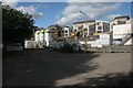
Houses under construction, Maryhill
Image: © Richard Sutcliffe
Taken: 8 Jul 2016
0.05 miles
5
Houses under construction, Maryhill
Image: © Richard Sutcliffe
Taken: 8 Jul 2016
0.05 miles
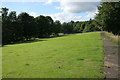
6
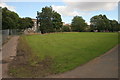
Amenity grassland, Maryhill
Looking from the Kelvin Walkway across amenity grassland towards where new houses are being built (behind the trees).
Image: © Richard Sutcliffe
Taken: 8 Jul 2016
0.05 miles
7
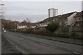
Cowal Road
Depending which map you look at, the road here is either Cowal Road or Skaethorn Road.
Image: © Richard Sutcliffe
Taken: 24 Mar 2016
0.06 miles
8
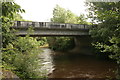
Bridge over the Kelvin
The bridge carries Cowal Road over the River Kelvin. Seen from the Kelvin Walkway.
Image: © Richard Sutcliffe
Taken: 8 Jul 2016
0.06 miles
9
Cowal Road
Depending which map you look at, the road here is either Cowal Road or Skaethorn Road. The dip in the road is where it crosses over the River Kelvin, before heading up to meet Maryhill Road (A81).
Image: © Richard Sutcliffe
Taken: 24 Mar 2016
0.07 miles
10
Amenity grassland, Maryhill
The River Kelvin is just beyond the trees on the left.
Image: © Richard Sutcliffe
Taken: 8 Jul 2016
0.07 miles