IMAGES TAKEN NEAR TO
Blairbuie Drive, GLASGOW, G20 0TY
Introduction
This page details the photographs taken nearby to Blairbuie Drive, G20 0TY by members of the Geograph project.
The Geograph project started in 2005 with the aim of publishing, organising and preserving representative images for every square kilometre of Great Britain, Ireland and the Isle of Man.

There are currently over 7.5m images from over14,400 individuals and you can help contribute to the project by visiting https://www.geograph.org.uk
Image Map
Images are licensed for reuse under creativecommons.org/licenses/by-sa/2.0
Notes
- Clicking on the map will re-center to the selected point.
- The higher the marker number, the further away the image location is from the centre of the postcode.
Image Listing (169 Images Found)
Images are licensed for reuse under creativecommons.org/licenses/by-sa/2.0
Image
Details
Distance
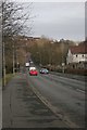
1
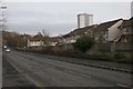
Cowal Road
Depending which map you look at, the road here is either Cowal Road or Skaethorn Road.
Image: © Richard Sutcliffe
Taken: 24 Mar 2016
0.00 miles
2
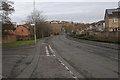
Cowal Road
Depending which map you look at, the main road here is either Cowal Road or Skaethorn Road. The road off to the left is Millhouse Drive.
Image: © Richard Sutcliffe
Taken: 24 Mar 2016
0.02 miles
3
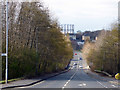
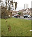
Cowal Road
Looking towards Kelvindale from Maryhill Road.
Image: © Thomas Nugent
Taken: 19 Mar 2016
0.05 miles
6
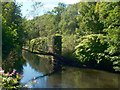
Remains of a bridge
The bridge pier that can be seen standing here in the River Kelvin is commented on in the Canmore database: https://canmore.org.uk/site/277656/glasgow-maryhill-caledonian-railway-bridge-over-river-kelvin
For a closer look, see Image
As shown on the first-edition OS map (c.1858) — https://maps.nls.uk/view/74479332 —, the bridge that stood here led from a Bridge Street, which was located just north of present-day Maryhill Locks, on the east side of the river, to a point just south of Dawsholm Printworks on the opposite side of the Kelvin. It was, at that time, a road bridge. There would later be a railway viaduct here, crossing the Kelvin at the same place, but at a different angle; the piers in the picture are presumably from that later viaduct.
Alexander Thompson, in "Rambling notes and random recollections ... of Maryhill, 1750-1894" (pub. 1895) appears to refer to the earlier road bridge as "the old bridge" in noting that "the Glasgow road passed down what is now Bridge Street, across the Kelvin, at first by means of a ford, afterwards by the old bridge, and thence through Dawsholm Printfield to a part called the Leechfauld, and continued across what is now part of the Garscube policies ..."
Image: © Lairich Rig
Taken: 30 Aug 2010
0.06 miles
7
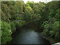
River Kelvin from Cowal Road
Those aren't birds in the photograph, they're midges!
Image: © Stephen Sweeney
Taken: 3 Sep 2007
0.06 miles
8
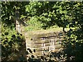
Remains of a bridge
See Image for context, and for the main description.
Image: © Lairich Rig
Taken: 30 Aug 2010
0.06 miles
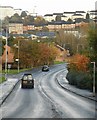
9
Cowal Road
Depending which map you look at, the road here is either Cowal Road or Skaethorn Road. The dip in the road is where it crosses over the River Kelvin, before heading up to meet Maryhill Road (A81).
Image: © Richard Sutcliffe
Taken: 24 Mar 2016
0.08 miles
10
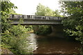
Bridge over the Kelvin
The bridge carries Cowal Road over the River Kelvin. Seen from the Kelvin Walkway.
Image: © Richard Sutcliffe
Taken: 8 Jul 2016
0.08 miles