IMAGES TAKEN NEAR TO
Acre Road, GLASGOW, G20 0TN
Introduction
This page details the photographs taken nearby to Acre Road, G20 0TN by members of the Geograph project.
The Geograph project started in 2005 with the aim of publishing, organising and preserving representative images for every square kilometre of Great Britain, Ireland and the Isle of Man.

There are currently over 7.5m images from over14,400 individuals and you can help contribute to the project by visiting https://www.geograph.org.uk
Image Map
Images are licensed for reuse under creativecommons.org/licenses/by-sa/2.0
Notes
- Clicking on the map will re-center to the selected point.
- The higher the marker number, the further away the image location is from the centre of the postcode.
Image Listing (77 Images Found)
Images are licensed for reuse under creativecommons.org/licenses/by-sa/2.0
Image
Details
Distance
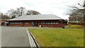
1
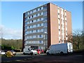
Acre Road flats
In the West of Scotland Science Park.
Image: © Stephen Sweeney
Taken: 25 Mar 2009
0.01 miles
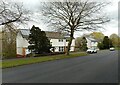
3
Flats, Acre Road
Numbers 63-67-71 and number 91 beyond.
Image: © Richard Sutcliffe
Taken: 10 Apr 2022
0.04 miles
4

Kelvin Hydrodynamics Laboratory
A facility run by the University of Strathclyde. The road leads to the University of Glasgow's Acre Road Observatory and their Argyll Wind Tunnel.
Image: © Richard Sutcliffe
Taken: 10 Apr 2022
0.05 miles
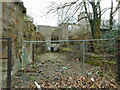
5
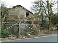
Dangerous building - keep out
The late 19th century house with 1960s additions has been empty for a long time and was put up for sale in 2005. It has seriously deteriorated since then and has been fire-damaged as well. The buttresses supporting the walls beside Acre Road are now rotten. Listed Building Consent for a residential development was being sought in 2020. The property is category C listed http://portal.historicenvironment.scot/designation/LB33727 and is also on the BARRS register https://www.buildingsatrisk.org.uk/details/906575.
Image: © Richard Sutcliffe
Taken: 10 Apr 2022
0.05 miles
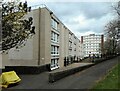
6
Block 3, Todd Campus
Alba Ultrasound and CPS Research.
Image: © Richard Sutcliffe
Taken: 10 Apr 2022
0.05 miles
7
Ruins of Acre House
The late 19th century house with 1960s additions has been empty for a long time and was put up for sale in 2005. It has seriously deteriorated since then and has been fire-damaged as well. Listed Building Consent for a residential development was being sought in 2020. The property is category C listed http://portal.historicenvironment.scot/designation/LB33727 and is also on the BARRS register https://www.buildingsatrisk.org.uk/details/906575.
Image: © Richard Sutcliffe
Taken: 10 Apr 2022
0.06 miles
8
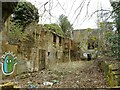
Ruins of Acre House
Viewed through a hole in the boundary wall. The late 19th century house with 1960s additions has been empty for a long time and was put up for sale in 2005. It has seriously deteriorated since then and has been fire-damaged as well. Listed Building Consent for a residential development was being sought in 2020. The property is category C listed http://portal.historicenvironment.scot/designation/LB33727 and is also on the BARRS register https://www.buildingsatrisk.org.uk/details/906575.
Image: © Richard Sutcliffe
Taken: 10 Apr 2022
0.06 miles
9
Block 1, Todd Campus
QCMD / Qnostics.
Image: © Richard Sutcliffe
Taken: 10 Apr 2022
0.07 miles
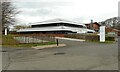
10
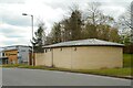
Building beside road, Todd Campus
It is not clear what this building at the West of Scotland Science Park is. The small courtyard on the left contained a portable generator.
Image: © Richard Sutcliffe
Taken: 10 Apr 2022
0.07 miles