IMAGES TAKEN NEAR TO
Dalsholm Road, GLASGOW, G20 0TB
Introduction
This page details the photographs taken nearby to Dalsholm Road, G20 0TB by members of the Geograph project.
The Geograph project started in 2005 with the aim of publishing, organising and preserving representative images for every square kilometre of Great Britain, Ireland and the Isle of Man.

There are currently over 7.5m images from over14,400 individuals and you can help contribute to the project by visiting https://www.geograph.org.uk
Image Map
Images are licensed for reuse under creativecommons.org/licenses/by-sa/2.0
Notes
- Clicking on the map will re-center to the selected point.
- The higher the marker number, the further away the image location is from the centre of the postcode.
Image Listing (65 Images Found)
Images are licensed for reuse under creativecommons.org/licenses/by-sa/2.0
Image
Details
Distance
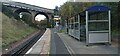
1
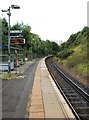
Kelvindale Station
The station is on the Glasgow Queen Street to Anniesland line. Originally opened in 1874 by the North British Railway, the line ran from Maryhill to Queens Dock. The line closed in 1980 and the track was lifted in 1987/8. The line was reinstated in 2005 as part of the Larkhall Branch reopening project.
Image: © Richard Sutcliffe
Taken: 8 Aug 2024
0.04 miles
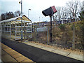
2
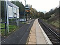
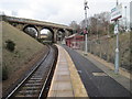
Kelvindale railway station
The penultimate station on the line from Queen Street to Anniesland. Single line and single platform.
Image: © Thomas Nugent
Taken: 31 Oct 2023
0.04 miles
3
Kelvindale railway station
The penultimate station on the line from Queen Street to Anniesland. Single line and single platform.
Image: © Thomas Nugent
Taken: 31 Oct 2023
0.04 miles
4
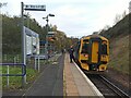
Kelvindale railway station
The penultimate station on the line from Queen Street to Anniesland. Single line and single platform. Scotrail Class 258 train numbered 158736 is heading to Anniesland.
Image: © Thomas Nugent
Taken: 31 Oct 2023
0.04 miles
5
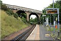
Kelvindale railway station
Looking towards the Dalsholm Road bridge.
Image: © Thomas Nugent
Taken: 31 Oct 2023
0.04 miles
6
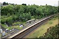
Kelvindale Station
Looking down on the station from the Dalsholm Road bridge.
The station is on the Glasgow Queen Street to Anniesland line. Originally opened in 1874 by the North British Railway, the line ran from Maryhill to Queens Dock. The line closed in 1980 and the track was lifted in 1987/8. The line was reinstated in 2005 as part of the Larkhall Branch reopening project.
Image: © Richard Sutcliffe
Taken: 8 Aug 2024
0.04 miles
7
Kelvindale railway station
On the Maryhill line, between Anniesland and Maryhill stations.
Image: © Thomas Nugent
Taken: 1 Mar 2014
0.04 miles
8
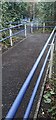
Ramps at Kelvindale railway station
Part of the elaborate arrangement of a chain of ramps and level sections which lead from street level to the station platform.
Image: © Thomas Nugent
Taken: 31 Oct 2023
0.05 miles
9
Kelvindale railway station, Glasgow
Opened in 2005 by British Rail as the extension of its line from Glasgow Queen Street (High Level) to Maryhill, services now run through to Anniesland. View east towards Maryhill and Queen Street.
Image: © Nigel Thompson
Taken: 15 Mar 2013
0.05 miles
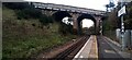
10
Dalsholm Road bridge
Crossing the railway at Kelvindale Station.
The station is on the Glasgow Queen Street to Anniesland line. Originally opened in 1874 by the North British Railway, the line ran from Maryhill to Queens Dock. The line closed in 1980 and the track was lifted in 1987/8. The line was reinstated in 2005 as part of the Larkhall Branch reopening project.
Image: © Richard Sutcliffe
Taken: 8 Aug 2024
0.05 miles