IMAGES TAKEN NEAR TO
Cadder Grove, GLASGOW, G20 0QW
Introduction
This page details the photographs taken nearby to Cadder Grove, G20 0QW by members of the Geograph project.
The Geograph project started in 2005 with the aim of publishing, organising and preserving representative images for every square kilometre of Great Britain, Ireland and the Isle of Man.

There are currently over 7.5m images from over14,400 individuals and you can help contribute to the project by visiting https://www.geograph.org.uk
Image Map
Images are licensed for reuse under creativecommons.org/licenses/by-sa/2.0
Notes
- Clicking on the map will re-center to the selected point.
- The higher the marker number, the further away the image location is from the centre of the postcode.
Image Listing (39 Images Found)
Images are licensed for reuse under creativecommons.org/licenses/by-sa/2.0
Image
Details
Distance
2
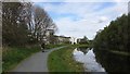
Forth and Clyde Canal
Here the canal runs beside the Lochburn Road. The towpath is wide and well surfaced and it was being heavily used.
Image: © Richard Webb
Taken: 9 May 2012
0.10 miles
4
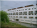
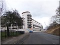
Lochburn Gate apartments
This new apartment complex was no doubt planned in happier economic times. The upper flats enjoy a view of the Forth and Clyde Canal.
Image: © Mark Nightingale
Taken: 20 Oct 2009
0.14 miles
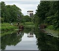
5
Stockingfield canal junction
This is looking along the Forth & Clyde Canal in the direction of Edinburgh (eventually). In the middle distance is the remains of a set of safety gates, installed during World War 2 to allow sections of the canal to be isolated in the event of bomb damage.
Image: © Stephen Craven
Taken: 25 Jun 2019
0.16 miles
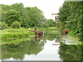
6
Stockingfield Stop Lock, Forth & Clyde Canal
The stop lock is one of several on the canal installed during the second world war.
According to Wikipedia [https://en.wikipedia.org/wiki/Stockingfield_Junction#The_Safety_Gates] 'In 1942 two massive steel safety gates were constructed on the Edinburgh side of Stockingfield Junction at what is known as the Stockingfield Narrows. The purpose of these two hand cranked steel gates was to hold back the waters of the Forth and Clyde Canal to prevent serious flooding in Glasgow in the event of bombing destroying the Stockingfield Aqueduct...'
In the distance are flats at the corner of Lochburn Road and cadder Road.
Image: © Richard Sutcliffe
Taken: 25 Jun 2019
0.16 miles
7
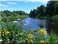
Stockingfield Junction, Forth & Clyde Canal
Wild flowers in profusion where the main canal heads off to Falkirk and the east, while the Glasgow city branch goes off to the right; to the left leads to Bowling and the River Clyde.
Image: © Gordon Brown
Taken: 24 Jul 2017
0.16 miles
8
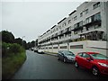
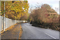
Lochburn Gate apartments
On Lochburn Road.
Image: © Richard Sutcliffe
Taken: 21 Jul 2017
0.17 miles
9
![Forth and Clyde Canal [27]](https://s1.geograph.org.uk/geophotos/06/24/92/6249249_5a4fbf1b_120x120.jpg)
Forth and Clyde Canal [27]
The Glasgow Branch of the canal (bottom right of the image) meets the main line at Stockingfield Junction. There are plans to build a new footbridge here to connect all three banks - see https://www.scottishcanals.co.uk/news/stockingfield-bridge/
The Forth and Clyde Canal was completed in 1790 and it provided a route for vessels between the Firth of Forth and the Firth of Clyde at the narrowest part (35 miles, 56km) of the Scottish Lowlands. Closed in 1963, the canal became semi-derelict. Millennium funds were used to regenerate the canal. The Glasgow Branch of the canal is a Scheduled Monument with details at: http://portal.historicenvironment.scot/designation/SM6771
Image: © Michael Dibb
Taken: 25 Jun 2019
0.17 miles
10
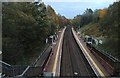
Gilsochill railway station
The station is between Summerston station and Possilpark & Parkhouse station on the Anniesland line from Queen Street.
Image: © Thomas Nugent
Taken: 31 Oct 2023
0.17 miles