IMAGES TAKEN NEAR TO
Lochburn Road, GLASGOW, G20 0QQ
Introduction
This page details the photographs taken nearby to Lochburn Road, G20 0QQ by members of the Geograph project.
The Geograph project started in 2005 with the aim of publishing, organising and preserving representative images for every square kilometre of Great Britain, Ireland and the Isle of Man.

There are currently over 7.5m images from over14,400 individuals and you can help contribute to the project by visiting https://www.geograph.org.uk
Image Map
Images are licensed for reuse under creativecommons.org/licenses/by-sa/2.0
Notes
- Clicking on the map will re-center to the selected point.
- The higher the marker number, the further away the image location is from the centre of the postcode.
Image Listing (6 Images Found)
Images are licensed for reuse under creativecommons.org/licenses/by-sa/2.0
Image
Details
Distance
1
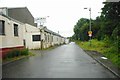
Lochburn Road
Industrial storage units are on the left. To the right of the road an embankment leads up to the Forth & Clyde Canal.
Image: © Richard Sutcliffe
Taken: 21 Jul 2017
0.05 miles
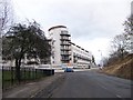
2
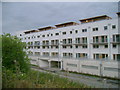
Lochburn Gate apartments
This new apartment complex was no doubt planned in happier economic times. The upper flats enjoy a view of the Forth and Clyde Canal.
Image: © Mark Nightingale
Taken: 20 Oct 2009
0.11 miles
3
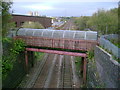
Footbridge over the Maryhill Line
A pedestrian footbridge over the Maryhill Line viewed from a second bridge which carries the Forth and Clyde Canal over the railway.
Image: © Mark Nightingale
Taken: 20 Oct 2009
0.12 miles
4
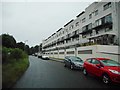
Lochburn Gate apartments
On Lochburn Road.
Image: © Richard Sutcliffe
Taken: 21 Jul 2017
0.14 miles
6
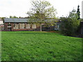
Cadder Primary School
On Herma Street, Glasgow.
Image: © G Laird
Taken: 23 Oct 2010
0.24 miles