IMAGES TAKEN NEAR TO
Sandbank Street, GLASGOW, G20 0NB
Introduction
This page details the photographs taken nearby to Sandbank Street, G20 0NB by members of the Geograph project.
The Geograph project started in 2005 with the aim of publishing, organising and preserving representative images for every square kilometre of Great Britain, Ireland and the Isle of Man.

There are currently over 7.5m images from over14,400 individuals and you can help contribute to the project by visiting https://www.geograph.org.uk
Image Map
Images are licensed for reuse under creativecommons.org/licenses/by-sa/2.0
Notes
- Clicking on the map will re-center to the selected point.
- The higher the marker number, the further away the image location is from the centre of the postcode.
Image Listing (19 Images Found)
Images are licensed for reuse under creativecommons.org/licenses/by-sa/2.0
Image
Details
Distance
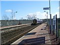
1
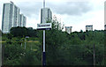
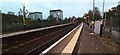
Summerston railway station
Towerblocks dominate the scene in this view from a train. The station is on the Anniesland line, between Maryhill and Gilshochill.
Image: © Thomas Nugent
Taken: 10 Aug 2013
0.20 miles
2

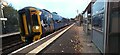
Summerston railway station
The station is between Kelvindale station and Gilsochill station on the Anniesland line from Queen Street. Scotrail Class 158 train numbered 158736 is departing for Queen Street.
Image: © Thomas Nugent
Taken: 31 Oct 2023
0.22 miles
3
Summerston railway station
The station is between Kelvindale station and Gilsochill station on the Anniesland line from Queen Street. Scotrail Class 158 train numbered 158736 is departing for Queen Street.
Image: © Thomas Nugent
Taken: 31 Oct 2023
0.22 miles
5
Summerston railway station
The station is on the Maryhill Line in the north of Glasgow.
Image: © Thomas Nugent
Taken: 19 Mar 2016
0.22 miles
6
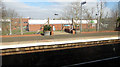
Summerston railway station
The station is between Kelvindale station and Gilsochill station on the Anniesland line from Queen Street.
Image: © Thomas Nugent
Taken: 31 Oct 2023
0.22 miles
7
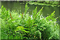
Royal Fern (Osmunda regalis)
There are apparently only two localities in Glasgow where this plant is found. Its spores are borne on separate fronds from the leaves; two such fronds are obvious towards the left here, but there are others among the leaves.
Image: © Anne Burgess
Taken: 25 Jun 2019
0.22 miles
8
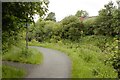
Royal Fern beside the Forth & Clyde Canal
A clump of the Royal Fern (Osmunda regalis) amongst other ferns beside the towpath. Two spore-bearing fronds can clearly be seen protruding above the leaves. See [https://www.geograph.org.uk/photo/6194451] for another view.
Image: © Richard Sutcliffe
Taken: 25 Jun 2019
0.22 miles
9
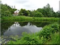
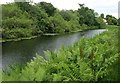
A bend on the Forth and Clyde Canal
There are blue signs for a cycle route on the left of the photograph.
Image: © Mark Anderson
Taken: 25 Jun 2019
0.22 miles
10
Train leaving Summerston station
Bound for Glasgow Queen Street.
Image: © Stephen Sweeney
Taken: 25 Mar 2009
0.23 miles