IMAGES TAKEN NEAR TO
Cumlodden Drive, GLASGOW, G20 0LA
Introduction
This page details the photographs taken nearby to Cumlodden Drive, G20 0LA by members of the Geograph project.
The Geograph project started in 2005 with the aim of publishing, organising and preserving representative images for every square kilometre of Great Britain, Ireland and the Isle of Man.

There are currently over 7.5m images from over14,400 individuals and you can help contribute to the project by visiting https://www.geograph.org.uk
Image Map
Images are licensed for reuse under creativecommons.org/licenses/by-sa/2.0
Notes
- Clicking on the map will re-center to the selected point.
- The higher the marker number, the further away the image location is from the centre of the postcode.
Image Listing (166 Images Found)
Images are licensed for reuse under creativecommons.org/licenses/by-sa/2.0
Image
Details
Distance
1
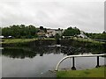
Maryhill Road from Maryhill Top Locks
Image: © Alec MacKinnon
Taken: 27 Jun 2023
0.06 miles

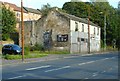
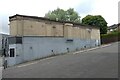
4
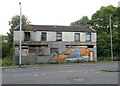
Derelict building, Maryhill Road
The former Horseshoe Bar Image continues to decline.
Image: © Richard Sutcliffe
Taken: 25 Jul 2024
0.06 miles
5
Maryhill Road Scotty Dog graffiti style mural
One of two murals on buildings on opposite sides of Maryhill Road. The brainchild of Maryhill and Summerston Community Council with support from Maryhill Housing Association. Funded by Glasgow City Council. Painted by local artists known as “art pistol” and “rogue one graffiti”.
See also Image & Image
Image: © Thomas Nugent
Taken: 19 Mar 2016
0.07 miles
6
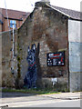
Maryhill Road Scotty Dog graffiti style mural
One of two murals on buildings on opposite sides of Maryhill Road. The brainchild of Maryhill and Summerston Community Council with support from Maryhill Housing Association. Funded by Glasgow City Council. Painted by local artists known as “art pistol” and “rogue one graffiti”.
See also Image & Image
Image: © Thomas Nugent
Taken: 19 Mar 2016
0.07 miles
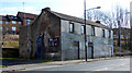
7
Derelict building, Maryhill Road
With Scotty Dog graffiti style mural, designed and painted by Art Pistol and Rogue One Graffiti.
Image: © Richard Sutcliffe
Taken: 3 Sep 2018
0.07 miles
8
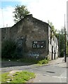
Derelict building
The building on Maryhill Road has been derelict for many years. It used to be a public house called The Redan.
For a better view of the mural on the wall, see Image
Image: © Richard Sutcliffe
Taken: 13 Sep 2021
0.07 miles
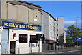
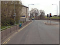
10
The Kelvin Dock
Located at the corner of Maryhill Road and Fingal Street, just opposite the real Kelvin Dock on the Forth and Clyde Canal. There has been a pub here since 1848. The tenements all around it were demolished many years ago and the bar was all that survived. It closed in May 2024 to make way for social housing.
Image: © Richard Sutcliffe
Taken: 25 Jul 2024
0.07 miles