IMAGES TAKEN NEAR TO
Duart Street, GLASGOW, G20 0EG
Introduction
This page details the photographs taken nearby to Duart Street, G20 0EG by members of the Geograph project.
The Geograph project started in 2005 with the aim of publishing, organising and preserving representative images for every square kilometre of Great Britain, Ireland and the Isle of Man.

There are currently over 7.5m images from over14,400 individuals and you can help contribute to the project by visiting https://www.geograph.org.uk
Image Map
Images are licensed for reuse under creativecommons.org/licenses/by-sa/2.0
Notes
- Clicking on the map will re-center to the selected point.
- The higher the marker number, the further away the image location is from the centre of the postcode.
Image Listing (70 Images Found)
Images are licensed for reuse under creativecommons.org/licenses/by-sa/2.0
Image
Details
Distance
1
NEW
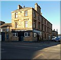
The First and Last
Public house on Maryhill Road. Either the first or last pub in Glasgow - depending on which way you're going.
Image: © Richard Sutcliffe
Taken: 12 Mar 2025
0.01 miles

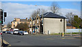
3

Maryhill Parish Church, Maryhill Road, Glasgow
Image: © Leslie Barrie
Taken: 29 Apr 2014
0.03 miles
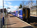
5
Maryhill railway station
The station is on the Maryhill Line in the north of Glasgow. Scotrail Class 156 train number 156453 is departing for Anniesland.
Image: © Thomas Nugent
Taken: 19 Mar 2016
0.06 miles
6
Maryhill railway station
The station is on the Maryhill Line in the north of Glasgow. Scotrail Class 156 train number 156453 is about to depart for Anniesland.
Image: © Thomas Nugent
Taken: 19 Mar 2016
0.06 miles
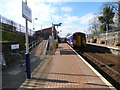
7
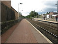
Maryhill railway station, looking South-West
View from platform 1 at Maryhill railway station, looking roughly South-West towards Anniesland.
Image: © Andrew Reid
Taken: 2 Sep 2011
0.06 miles
8
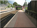
Maryhill railway station, looking North-East
View from platform 1 at Maryhill railway station, looking roughly North-East towards Glasgow Queen Street.
Image: © Andrew Reid
Taken: 2 Sep 2011
0.06 miles
9
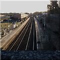
NEW
Maryhill Station
The station is on the Glasgow Queen Street to Anniesland line. Seen from the Maryhill Road bridge.
Image: © Richard Sutcliffe
Taken: 12 Mar 2025
0.07 miles
10
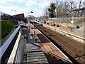
Maryhill railway station
The station is on the Maryhill Line in the north of Glasgow.
Image: © Thomas Nugent
Taken: 19 Mar 2016
0.07 miles