IMAGES TAKEN NEAR TO
G20 0BL
Introduction
This page details the photographs taken nearby to G20 0BL by members of the Geograph project.
The Geograph project started in 2005 with the aim of publishing, organising and preserving representative images for every square kilometre of Great Britain, Ireland and the Isle of Man.

There are currently over 7.5m images from over14,400 individuals and you can help contribute to the project by visiting https://www.geograph.org.uk
Image Map
Images are licensed for reuse under creativecommons.org/licenses/by-sa/2.0
Notes
- Clicking on the map will re-center to the selected point.
- The higher the marker number, the further away the image location is from the centre of the postcode.
Image Listing (193 Images Found)
Images are licensed for reuse under creativecommons.org/licenses/by-sa/2.0
Image
Details
Distance
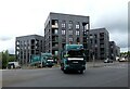
1

New homes under construction
A multi-million pound development at the corner of Maryhill Road and Cowal Road, which began in late 2020. According to the Cruden Group's website, it is part of a project by Maryhill Housing and Cruden Building to provide 62 affordable new homes. 18 of these will be low-cost home ownership properties and another 18 will be mid-market rent properties. The remaining 26 properties will be for social rent, with six of these designed to be easily adapted for full wheelchair use.
Image: © Richard Sutcliffe
Taken: 13 Sep 2021
0.01 miles
2
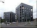
New blocks of apartments
At the corner of Maryhill Road and Cowal Road.
Image: © Richard Sutcliffe
Taken: 25 Jul 2024
0.02 miles
4
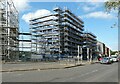
New homes under construction
A multi-million pound development at the corner of Maryhill Road and Cowal Road, which began in late 2020. According to the Cruden Group's website, it is part of a project by Maryhill Housing and Cruden Building to provide 62 affordable new homes. 18 of these will be low-cost home ownership properties and another 18 will be mid-market rent properties. The remaining 26 properties will be for social rent, with six of these designed to be easily adapted for full wheelchair use.
Image: © Richard Sutcliffe
Taken: 13 Sep 2021
0.02 miles
5
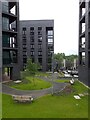
New blocks of apartments on Maryhill Road
Image: © Richard Sutcliffe
Taken: 25 Jul 2024
0.02 miles
6
Bin lorries
Two City of Glasgow Council bin lorries turning onto Maryhill Road from Cowal Road. New apartments are behind them.
Image: © Richard Sutcliffe
Taken: 25 Jul 2024
0.02 miles
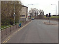
7
Housing development in Maryhill
On Whitelaw Street, viewed from Maryhill Road at Cowal Road.
Image: © Thomas Nugent
Taken: 19 Mar 2016
0.02 miles

9
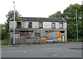
Derelict building, Maryhill Road
The former Horseshoe Bar Image continues to decline.
Image: © Richard Sutcliffe
Taken: 25 Jul 2024
0.03 miles
10
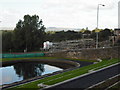
Maryhill canal basin
With view to the redevelopment at Whitelaw Street.
Image: © Jim Smillie
Taken: 9 Sep 2009
0.03 miles