IMAGES TAKEN NEAR TO
Bantaskin Street, GLASGOW, G20 0BE
Introduction
This page details the photographs taken nearby to Bantaskin Street, G20 0BE by members of the Geograph project.
The Geograph project started in 2005 with the aim of publishing, organising and preserving representative images for every square kilometre of Great Britain, Ireland and the Isle of Man.

There are currently over 7.5m images from over14,400 individuals and you can help contribute to the project by visiting https://www.geograph.org.uk
Image Map
Images are licensed for reuse under creativecommons.org/licenses/by-sa/2.0
Notes
- Clicking on the map will re-center to the selected point.
- The higher the marker number, the further away the image location is from the centre of the postcode.
Image Listing (188 Images Found)
Images are licensed for reuse under creativecommons.org/licenses/by-sa/2.0
Image
Details
Distance
1

Cowal Road
Looking towards Kelvindal from Maryhill Road.
Image: © Thomas Nugent
Taken: 19 Mar 2016
0.02 miles
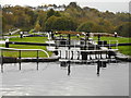
2
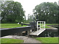
The Forth & Clyde Canal
The upper gate of lock 24 at Maryhill.
Image: © M J Richardson
Taken: 25 Jun 2019
0.03 miles
3
Maryhill locks, Forth and Clyde Canal
Image: © Clive Nicholson
Taken: 17 Jun 2014
0.04 miles
4
Lock 24, Forth & Clyde Canal
With the gasholders of the Temple Gasworks in the distance Image
Image: © M J Richardson
Taken: 25 Jun 2019
0.04 miles
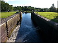
5
The Forth and Clyde Canal at Maryhill
Looking down the locks towards Kelvindale from Maryhill Road.
Image: © Thomas Nugent
Taken: 19 Mar 2016
0.04 miles
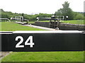
6
Lock 24, Forth & Clyde Canal
One of the flight of five locks at Maryhill constructed between 1787 and 1790.
Image: © Richard Sutcliffe
Taken: 16 Oct 2017
0.04 miles
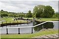
7
![Forth and Clyde Canal [36]](https://s2.geograph.org.uk/geophotos/06/24/92/6249270_dc6bd43c_120x120.jpg)
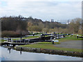
Forth and Clyde Canal [36]
Locks 24 and 25 at Maryhill with the Kelvin River Aqueduct beyond.
The Forth and Clyde Canal was completed in 1790 and it provided a route for vessels between the Firth of Forth and the Firth of Clyde at the narrowest part (35 miles, 56km) of the Scottish Lowlands. Closed in 1963, the canal became semi-derelict. Millennium funds were used to regenerate the canal. The main line of the canal is a Scheduled Monument with details at: http://portal.historicenvironment.scot/designation/SM6773
Image: © Michael Dibb
Taken: 25 Jun 2019
0.04 miles
9
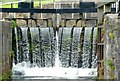
Cascading water, Lock 25, Maryhill
The lock gates on the Forth and Clyde Canal are designed to allow excess water in the Canal to overflow, rather than a separate overflow spillway being constructed.
Image: © Alan Murray-Rust
Taken: 25 Jun 2019
0.04 miles
10
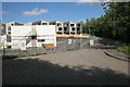
Houses under construction, Maryhill
Cowal Street is on the right.
Image: © Richard Sutcliffe
Taken: 8 Jul 2016
0.04 miles