IMAGES TAKEN NEAR TO
Drumry Place, GLASGOW, G15 8PP
Introduction
This page details the photographs taken nearby to Drumry Place, G15 8PP by members of the Geograph project.
The Geograph project started in 2005 with the aim of publishing, organising and preserving representative images for every square kilometre of Great Britain, Ireland and the Isle of Man.

There are currently over 7.5m images from over14,400 individuals and you can help contribute to the project by visiting https://www.geograph.org.uk
Image Map
Images are licensed for reuse under creativecommons.org/licenses/by-sa/2.0
Notes
- Clicking on the map will re-center to the selected point.
- The higher the marker number, the further away the image location is from the centre of the postcode.
Image Listing (38 Images Found)
Images are licensed for reuse under creativecommons.org/licenses/by-sa/2.0
Image
Details
Distance
1
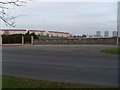
Drumchapel from Great Western Road
Looking to Drumry Road East and the Linkwood Flats.
Image: © Stephen Sweeney
Taken: 19 Feb 2008
0.04 miles
2
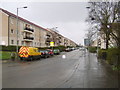
View along Drumry Road East
The main road into Drumchapel from the Clydebank direction. You can see the results of the Drumchapel renovation project in the houses on this road.
Image: © Stephen Sweeney
Taken: 12 Mar 2007
0.07 miles
3
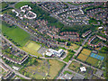
Drumchapel from the air
Antonine Primary School is in the centre. The blue tennis courts are in Drumchapel park.
Image: © Thomas Nugent
Taken: 6 May 2019
0.09 miles
4
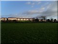
Drumchapel from Drumry
Looking to Drumry Road East.
Image: © Stephen Sweeney
Taken: 27 Feb 2008
0.11 miles
5

Drumchapel from the air
Just off Great Western Road.
Image: © Thomas Nugent
Taken: 1 May 2017
0.15 miles
6
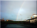
Drumchapel with Rainbow
Rainbow over the western edge of Drumchapel 2004
Image: © bill
Taken: 4 Nov 2004
0.15 miles
7
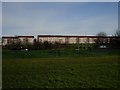
Housing in Drumchapel
Looking over from behind the BMX track in Drumry.
Image: © Stephen Sweeney
Taken: 19 Mar 2008
0.16 miles
8
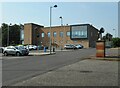
Drumchapel Police Station
On the right is a sculpture on a brick plinth, which had something to do with the former Drumchapel Social Work Area Office, which was adjacent to it, but which has been demolished.
Image: © Richard Sutcliffe
Taken: 6 Sep 2023
0.16 miles
9
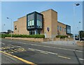
Drumchapel Police Station
On Drumry Road East.
Image: © Richard Sutcliffe
Taken: 6 Sep 2023
0.16 miles
10
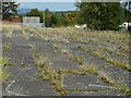
Grass growing between the slabs
Beside the site of the former Drumchapel Social Work Area Office.
Image: © Richard Sutcliffe
Taken: 6 Sep 2023
0.17 miles