IMAGES TAKEN NEAR TO
Laurence Court, GLASGOW, G15 8AG
Introduction
This page details the photographs taken nearby to Laurence Court, G15 8AG by members of the Geograph project.
The Geograph project started in 2005 with the aim of publishing, organising and preserving representative images for every square kilometre of Great Britain, Ireland and the Isle of Man.

There are currently over 7.5m images from over14,400 individuals and you can help contribute to the project by visiting https://www.geograph.org.uk
Image Map
Images are licensed for reuse under creativecommons.org/licenses/by-sa/2.0
Notes
- Clicking on the map will re-center to the selected point.
- The higher the marker number, the further away the image location is from the centre of the postcode.
Image Listing (34 Images Found)
Images are licensed for reuse under creativecommons.org/licenses/by-sa/2.0
Image
Details
Distance
1
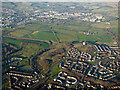
Drumchapel from the air
Drumchapel is in the foreground, Hardgate and Faifley are in the background.
Image: © Thomas Nugent
Taken: 4 Dec 2016
0.06 miles
2
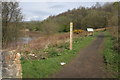
The Drumchapel Way, Cleddans Burn
Start of the Drumchapel Way - a 7km circular route around the outskirts of Drumchapel.
Image: © Richard Sutcliffe
Taken: 14 Apr 2017
0.09 miles
3
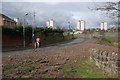
Horse and rider
A horse and rider walk down the road to the Great Western Golf driving range, having just left the Drumchapel Way path behind the photographer. Apparently most people think it strange to see horses in Drumchapel.
Image: © Richard Sutcliffe
Taken: 14 Apr 2017
0.10 miles
4
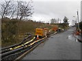
Pumps, Cleddans Burn
Pumps not in use at the time, possibly a response to recent flooding. The road leads to five a side football pitches all branded with famous stadia. I did not see Edgar Street for some reason.
Image: © Richard Webb
Taken: 4 Jan 2016
0.10 miles
5
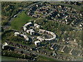
Drumchapel from the air
Laurence Court and Laurence gardens are the distinctive streets in this view.
Image: © Thomas Nugent
Taken: 24 Apr 2022
0.11 miles
6
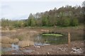
Marshy area, Cleddans Burn
At the south-western point of the Drumchapel Way - a 7km circular route around the outskirts of Drumchapel. The muddy area in the foreground is a result of a recent diversion of the culverted Cleddans Burn to the south of this point.
A horse and rider are enjoying a hack along the path.
Image: © Richard Sutcliffe
Taken: 14 Apr 2017
0.11 miles
7
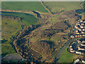
Cleddans Burn from the air
On the western fringes of Drunchapel.
Image: © Thomas Nugent
Taken: 4 Dec 2016
0.12 miles
8
Marshy area, Cleddans Burn
At the south-western point of the Drumchapel Way - a 7km circular route around the outskirts of Drumchapel. The muddy area in the foreground is a result of a recent diversion of the culverted Cleddans Burn to the south of this point.
Image: © Richard Sutcliffe
Taken: 14 Apr 2017
0.13 miles
9
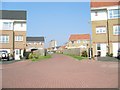
Bernisdale Place, Drumchapel
New housing development - so new, it is yet to appear on the OS map.
Image: © Stephen Sweeney
Taken: 8 May 2008
0.14 miles
10
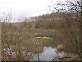
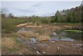
Flooded marsh, Cleddans Burn
Water had been pumped out of here. It is mapped as a marsh.
Image: © Richard Webb
Taken: 4 Jan 2016
0.14 miles