IMAGES TAKEN NEAR TO
Peel Glen Road, GLASGOW, G15 7XW
Introduction
This page details the photographs taken nearby to Peel Glen Road, G15 7XW by members of the Geograph project.
The Geograph project started in 2005 with the aim of publishing, organising and preserving representative images for every square kilometre of Great Britain, Ireland and the Isle of Man.

There are currently over 7.5m images from over14,400 individuals and you can help contribute to the project by visiting https://www.geograph.org.uk
Image Map
Images are licensed for reuse under creativecommons.org/licenses/by-sa/2.0
Notes
- Clicking on the map will re-center to the selected point.
- The higher the marker number, the further away the image location is from the centre of the postcode.
Image Listing (39 Images Found)
Images are licensed for reuse under creativecommons.org/licenses/by-sa/2.0
Image
Details
Distance
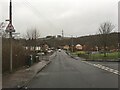
2
Summerhill Road
Viewed from the junction with Peel Glen Road.
Image: © Richard Sutcliffe
Taken: 14 Jan 2017
0.01 miles
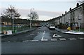
3
Peel Glen Road
Ladyloan Avenue is on the left.
Image: © Richard Sutcliffe
Taken: 14 Jan 2017
0.01 miles
4
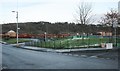
Houses and greenspace
Houses on Springside Place and greenspace off Peel Glen Road.
Image: © Richard Sutcliffe
Taken: 14 Jan 2017
0.02 miles
5
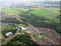
Garscadden Wood, Bearsden
With housing estates on the edge of Bearsden.
Image: © M J Richardson
Taken: 23 Jul 2016
0.04 miles
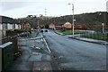
7
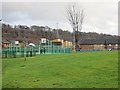
Summerhill Road
Park and flats off Peel Glen Road.
Image: © Richard Webb
Taken: 19 Jan 2014
0.06 miles
8
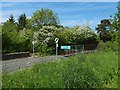
Peel Glen Road
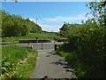
The road separates the two halves of Garscadden Wood: Garscadden Wood (East) is on its near side.
The sign beside the road says Garscadden Burn Park, but this is incorrect. The Garscadden Burn is over a kilometre to the south, as is the area of woodland that is named after it; see the end-notes.
Image itself is nearby, on the west side of the road. The eponymous Peel (Drumry Peel Tower, at c.Image) was demolished in the 1950s.
Image: © Lairich Rig
Taken: 12 Jun 2015
0.10 miles
9
Paths beside Peel Glen Road
Peel Glen Road, visible just ahead, separates the two halves (East and West) of Garscadden Wood; Garscadden Wood (West) is on the near side of the road.
The paths are shown on large-scale OS mapping.
Image: © Lairich Rig
Taken: 12 Jun 2015
0.10 miles
10
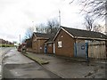
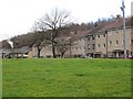
Police station, Kinfauns Drive
Now closed and boarded up.
Image: © Richard Webb
Taken: 19 Jan 2014
0.12 miles