IMAGES TAKEN NEAR TO
Dewar Gate, GLASGOW, G15 7TL
Introduction
This page details the photographs taken nearby to Dewar Gate, G15 7TL by members of the Geograph project.
The Geograph project started in 2005 with the aim of publishing, organising and preserving representative images for every square kilometre of Great Britain, Ireland and the Isle of Man.

There are currently over 7.5m images from over14,400 individuals and you can help contribute to the project by visiting https://www.geograph.org.uk
Image Map
Images are licensed for reuse under creativecommons.org/licenses/by-sa/2.0
Notes
- Clicking on the map will re-center to the selected point.
- The higher the marker number, the further away the image location is from the centre of the postcode.
Image Listing (49 Images Found)
Images are licensed for reuse under creativecommons.org/licenses/by-sa/2.0
Image
Details
Distance
1
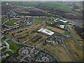
Drumchapel from the air
Drumchapel High School is an island amongst the brownfield sites.
Image: © Thomas Nugent
Taken: 24 Feb 2017
0.02 miles
2
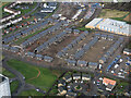
Drumchapel from the air
New houses on the site of old. See the scene in November 2017 Image
Image: © Thomas Nugent
Taken: 24 Jan 2020
0.04 miles
3
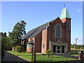
Saint Pius X Church
Roman Catholic church in Drumchapel
Image: © Chris Upson
Taken: 23 Sep 2005
0.07 miles
4
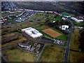
Drumchapel High School from the air
A new building in the middle of a brownfield desert. Here is a http://www.drumchapelhigh.glasgow.sch.uk/ to the school's web site.
Image: © Thomas Nugent
Taken: 3 Nov 2017
0.09 miles
5
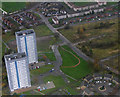
Linkwood Crescent towerblocks from the air
The two surviving towerblocks on Linkwood Crescent. A third one stood at the far side of the further block, it was demolished in February 2017.
April 2016 Image]
February 2017 Image]
Image: © Thomas Nugent
Taken: 3 Nov 2017
0.09 miles
6
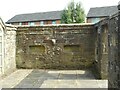
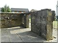
Campbell Colquhoun burial ground
Category B listed https://portal.historicenvironment.scot/designation/LB43030 remains of the Campbell Colquhoun burial ground. Probably dating from the 16th century, the remains are behind iron railings, immediately to the east of a tower block at 39 Linkswood Crescent.
The remains are located within the former grounds of Garscadden House (long demolished). Maintenance of the burial ground is the responsibility of Glasgow City Council, who acquired the land in 1959.
Image: © Richard Sutcliffe
Taken: 6 Sep 2023
0.10 miles
7
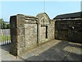
Campbell Colquhoun burial ground
Category B listed https://portal.historicenvironment.scot/designation/LB43030 remains of the Campbell Colquhoun burial ground. Probably dating from the 16th century, the remains are behind iron railings, immediately to the east of a tower block at 39 Linkswood Crescent.
The remains are located within the former grounds of Garscadden House (long demolished). Maintenance of the burial ground is the responsibility of Glasgow City Council, who acquired the land in 1959.
Image: © Richard Sutcliffe
Taken: 6 Sep 2023
0.10 miles
8
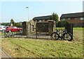
Campbell Colquhoun burial ground
Category B listed https://portal.historicenvironment.scot/designation/LB43030 remains of the Campbell Colquhoun burial ground. Probably dating from the 16th century, the remains are behind iron railings, immediately to the east of a tower block at 39 Linkswood Crescent.
The remains are located within the former grounds of Garscadden House (long demolished). Maintenance of the burial ground is the responsibility of Glasgow City Council, who acquired the land in 1959.
Image: © Richard Sutcliffe
Taken: 6 Sep 2023
0.10 miles
9

Linkwood Flats, Drumchapel
High flats in the middle of Drumchapel.
Image: © Stephen Sweeney
Taken: 12 Mar 2007
0.10 miles
10
Campbell Colquhoun burial ground
Category B listed https://portal.historicenvironment.scot/designation/LB43030 remains of the Campbell Colquhoun burial ground. Probably dating from the 16th century, the remains are behind iron railings, immediately to the east of a tower block at 39 Linkswood Crescent.
The remains are located within the former grounds of Garscadden House (long demolished). Maintenance of the burial ground is the responsibility of Glasgow City Council, who acquired the land in 1959.
Image: © Richard Sutcliffe
Taken: 6 Sep 2023
0.10 miles