IMAGES TAKEN NEAR TO
Southdeen Avenue, GLASGOW, G15 7RH
Introduction
This page details the photographs taken nearby to Southdeen Avenue, G15 7RH by members of the Geograph project.
The Geograph project started in 2005 with the aim of publishing, organising and preserving representative images for every square kilometre of Great Britain, Ireland and the Isle of Man.

There are currently over 7.5m images from over14,400 individuals and you can help contribute to the project by visiting https://www.geograph.org.uk
Image Map
Images are licensed for reuse under creativecommons.org/licenses/by-sa/2.0
Notes
- Clicking on the map will re-center to the selected point.
- The higher the marker number, the further away the image location is from the centre of the postcode.
Image Listing (16 Images Found)
Images are licensed for reuse under creativecommons.org/licenses/by-sa/2.0
Image
Details
Distance
1
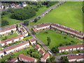
Tallant Road and Kinfauns Drive
A housing estate at Drumchapel from the air.
Image: © M J Richardson
Taken: 20 Jun 2015
0.03 miles
3
Start of Kinfauns Drive, Drumchapel
The main road that runs right through Drumchapel.
Image: © Stephen Sweeney
Taken: 2 Aug 2007
0.13 miles
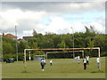
4
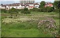
Garscadden Burn Park
Looking along the line of the Garscadden Burn, which is difficult to see due to the abundance of vegetation. Most of the park is a City-wide Site of Importance for Nature Conservation, centred around the burn, which supports a population of water voles.
Image: © Richard Sutcliffe
Taken: 29 Jul 2024
0.15 miles
5
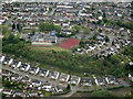
Colquhoun Park Primary School from the air
The school is located on Canniesburn Road. Annan Drive is in the foreground.
School web site: http://www.colquhounpark.e-dunbarton.sch.uk/ .
Image: © Thomas Nugent
Taken: 5 May 2022
0.15 miles
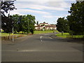
6
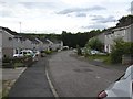
Annick Drive
A culdesac off Canniesburn Road.
Image: © Richard Sutcliffe
Taken: 10 Jul 2015
0.18 miles
7

Entering Bearsden
The boundary between City of Glasgow and Bearsden (East Dunbartonshire) on Canniesburn Road.
Image: © Richard Sutcliffe
Taken: 10 Jul 2015
0.18 miles
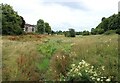
8
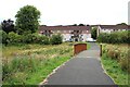
Bridge over the Garscadden Burn
The houses are on Southdeen Avenue.
Image: © Richard Sutcliffe
Taken: 29 Jul 2024
0.19 miles
10
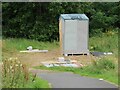
A new doo house
A new pigeon (doo) loft being built within Garscadden Burn Park. Although not quite complete it appears to have at least one doo in residence.
Image: © Richard Sutcliffe
Taken: 29 Jul 2024
0.20 miles