IMAGES TAKEN NEAR TO
Goyle Avenue, GLASGOW, G15 7NU
Introduction
This page details the photographs taken nearby to Goyle Avenue, G15 7NU by members of the Geograph project.
The Geograph project started in 2005 with the aim of publishing, organising and preserving representative images for every square kilometre of Great Britain, Ireland and the Isle of Man.

There are currently over 7.5m images from over14,400 individuals and you can help contribute to the project by visiting https://www.geograph.org.uk
Image Map
Images are licensed for reuse under creativecommons.org/licenses/by-sa/2.0
Notes
- Clicking on the map will re-center to the selected point.
- The higher the marker number, the further away the image location is from the centre of the postcode.
Image Listing (21 Images Found)
Images are licensed for reuse under creativecommons.org/licenses/by-sa/2.0
Image
Details
Distance
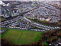
1
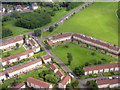
Tallant Road and Kinfauns Drive
A housing estate at Drumchapel from the air.
Image: © M J Richardson
Taken: 20 Jun 2015
0.11 miles
2
Drummore Road
Seen from beside the junction with Station Road/Chesters Road.
Image: © Richard Sutcliffe
Taken: 27 Dec 2021
0.13 miles
3
Colquhoun Park Primary School from the air
The school is located on Canniesburn Road. Annan Drive is in the foreground.
School web site: http://www.colquhounpark.e-dunbarton.sch.uk/ .
Image: © Thomas Nugent
Taken: 5 May 2022
0.13 miles
4
Station Road
Colquhoun Park is to the right.
Image: © Richard Sutcliffe
Taken: 27 Dec 2021
0.14 miles
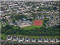
5
Colquhoun Park from the air
The railway junction west of Westerton station can be seen at the top of the photo, as can the Forth & Clyde canal.
Image: © Thomas Nugent
Taken: 17 Nov 2017
0.16 miles
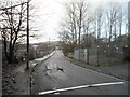
6
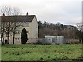
Flats, Drummore Road
A partly built up area on a glen floor with surrounding steep slopes. I would expect this to be a rather cold place. Bearsden is nearby, behind the trees in the background at the top of a steep slope.
Image: © Richard Webb
Taken: 19 Jan 2014
0.17 miles
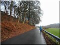
7
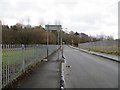
Drummore Road
The road to Bearsden runs between two fenced off areas. The one on the left is decorated with shiny dinosaur shapes and is a school grounds of sort.
Image: © Richard Webb
Taken: 19 Jan 2014
0.17 miles
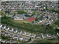
8
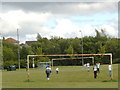
Colquhoun Park Primary School from the air
Some children can be seen on the sports field. Annan Drive is in the foreground.
School web site: http://www.colquhounpark.e-dunbarton.sch.uk/ .
Image: © Thomas Nugent
Taken: 6 Sep 2019
0.17 miles
10
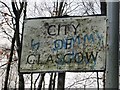
Battered sign
City of Glasgow boundary sign at the foot of Chesters Road. Here begins the long slog up to Bearsden and another world.
Image: © Richard Webb
Taken: 19 Jan 2014
0.18 miles