IMAGES TAKEN NEAR TO
Bayfield Avenue, GLASGOW, G15 7AE
Introduction
This page details the photographs taken nearby to Bayfield Avenue, G15 7AE by members of the Geograph project.
The Geograph project started in 2005 with the aim of publishing, organising and preserving representative images for every square kilometre of Great Britain, Ireland and the Isle of Man.

There are currently over 7.5m images from over14,400 individuals and you can help contribute to the project by visiting https://www.geograph.org.uk
Image Map (Loading...)


Getting Data...Please wait
Leaflet Map data © OpenStreetMap
Images are licensed for reuse under creativecommons.org/licenses/by-sa/2.0
Notes
- Clicking on the map will re-center to the selected point.
- The higher the marker number, the further away the image location is from the centre of the postcode.
Image Listing (51 Images Found)
Images are licensed for reuse under creativecommons.org/licenses/by-sa/2.0
Image
Details
Distance
1
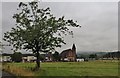
A Drumchapel church in land cleared of housing
Roads, pavements and street lights remain to show where the housing scheme once stood
Image: © Alan Reid
Taken: 12 Sep 2013
0.05 miles
2
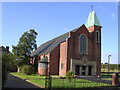
Saint Pius X Church
Roman Catholic church in Drumchapel
Image: © Chris Upson
Taken: 23 Sep 2005
0.05 miles
3
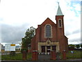
St. Pius X Church in Drumchapel
The sign on the left says the building is being converted into a 30 bed dementia unit.
Image: © Darrin Antrobus
Taken: 22 May 2007
0.06 miles
4
Drumchapel High School
On Cally Avenue, Drumchapel High School is a comprehensive non-denominational school. It moved into a purpose built new school about five years ago, with space for 850 pupils.
Image: © G Laird
Taken: 26 Dec 2013
0.06 miles
5
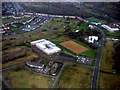
Drumchapel High School from the air
A new building in the middle of a brownfield desert. Here is a http://www.drumchapelhigh.glasgow.sch.uk/ to the school's web site.
Image: © Thomas Nugent
Taken: 3 Nov 2017
0.07 miles
6

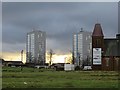
Linkwood Flats, Drumchapel
High flats in the middle of Drumchapel.
Image: © Stephen Sweeney
Taken: 12 Mar 2007
0.07 miles
7
Empty streets, Drumchapel
A large area of former housing and a former church, now demolished off Kinfauns Drive.
Image: © Richard Webb
Taken: 19 Jan 2014
0.08 miles
8
Drumchapel High School from the air
Seen from the right-hand side of an aircraft on approach to Runway 23 at Glasgow Airport.
Image: © M J Richardson
Taken: 3 Oct 2015
0.09 miles
9
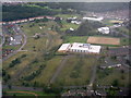
Drumchapel from the air
Drumchapel High School is an island amongst the brownfield sites.
Image: © Thomas Nugent
Taken: 24 Feb 2017
0.09 miles
10
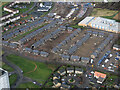
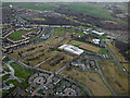
Drumchapel from the air
New houses on the site of old. See the scene in November 2017 Image
Image: © Thomas Nugent
Taken: 24 Jan 2020
0.11 miles