IMAGES TAKEN NEAR TO
Sunnyside Drive, GLASGOW, G15 6QZ
Introduction
This page details the photographs taken nearby to Sunnyside Drive, G15 6QZ by members of the Geograph project.
The Geograph project started in 2005 with the aim of publishing, organising and preserving representative images for every square kilometre of Great Britain, Ireland and the Isle of Man.

There are currently over 7.5m images from over14,400 individuals and you can help contribute to the project by visiting https://www.geograph.org.uk
Image Map
Images are licensed for reuse under creativecommons.org/licenses/by-sa/2.0
Notes
- Clicking on the map will re-center to the selected point.
- The higher the marker number, the further away the image location is from the centre of the postcode.
Image Listing (50 Images Found)
Images are licensed for reuse under creativecommons.org/licenses/by-sa/2.0
Image
Details
Distance
1
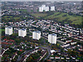
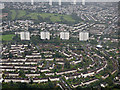
Great Western Road from the air
The towerblocks in the foreground are at Keal Crescent
Image: © Thomas Nugent
Taken: 13 Oct 2012
0.07 miles
2
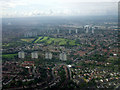
Knightswood from the air
Looking over Drumchapel and the A82, Knightswood Park golf course in the distance.
Image: © Thomas Nugent
Taken: 9 Jun 2012
0.07 miles
3
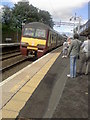
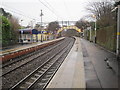
Drumchapel railway station, looking WNW
Drumchapel railway station, looking roughly WNW. 320 310 is approaching platform 1 with the 11:23 service to Airdrie.
Image: © Andrew Reid
Taken: 8 Aug 2011
0.07 miles
5
Blairdardie from the air
The four towerblocks on Keal Crescent by the A82 Great Western Road are prominent, with Knightswood golf course beyond.
Image: © Thomas Nugent
Taken: 6 Sep 2019
0.08 miles
6
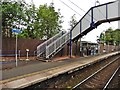
Footbridge at Drumchapel railway station
Image: © Roger Cornfoot
Taken: 19 Jun 2018
0.10 miles
7
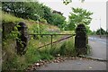
Former entrance ramp to hospital
Beyond the gate piers a ramp led up to the former Country Branch of the Royal Hospital for Sick Children, which opened in 1903. Eventually becoming a gereatric hospital, it closed in 2016 and was subsequently demolished. See https://en.wikipedia.org/wiki/Drumchapel_Hospital.
Image: © Richard Sutcliffe
Taken: 29 Jul 2024
0.10 miles
8
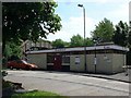
Drumchapel railway station
Drumchapel railway station building, taken in mid 2006
Image: © Kenneth Delman
Taken: Unknown
0.11 miles
9
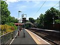
Drumchapel railway station, Glasgow
Opened in 1890 by the North British Railway on its line from Dalmuir to Glasgow via Westerton. View east towards Westerton.
Image: © Nigel Thompson
Taken: 29 Dec 2012
0.12 miles
10
Drumchapel railway station
Drumchapel railway station, eastbound platform.
Image: © Kenneth Delman
Taken: Unknown
0.12 miles