IMAGES TAKEN NEAR TO
Firdon Crescent, GLASGOW, G15 6QQ
Introduction
This page details the photographs taken nearby to Firdon Crescent, G15 6QQ by members of the Geograph project.
The Geograph project started in 2005 with the aim of publishing, organising and preserving representative images for every square kilometre of Great Britain, Ireland and the Isle of Man.

There are currently over 7.5m images from over14,400 individuals and you can help contribute to the project by visiting https://www.geograph.org.uk
Image Map (Loading...)


Getting Data...Please wait
Leaflet Map data © OpenStreetMap
Images are licensed for reuse under creativecommons.org/licenses/by-sa/2.0
Notes
- Clicking on the map will re-center to the selected point.
- The higher the marker number, the further away the image location is from the centre of the postcode.
Image Listing (51 Images Found)
Images are licensed for reuse under creativecommons.org/licenses/by-sa/2.0
Image
Details
Distance
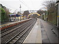
2
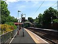
Drumchapel railway station
Drumchapel railway station, eastbound platform.
Image: © Kenneth Delman
Taken: Unknown
0.04 miles
3
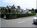
Housing on Garscadden Road
In Old Drumchapel.
Image: © Stephen Sweeney
Taken: 6 May 2008
0.04 miles
4
Drumchapel Railway Station
The station between Westerton and Drumry railway stations on both the Argyle line and the North Clyde line.
Image: © G Laird
Taken: 26 Dec 2013
0.04 miles
5
Old Drumchapel housing
On Garscadden Road.
Image: © Stephen Sweeney
Taken: 6 May 2008
0.05 miles
6
Drumchapel railway station, Glasgow
Opened in 1890 by the North British Railway on its line from Dalmuir to Glasgow via Westerton. View east towards Westerton.
Image: © Nigel Thompson
Taken: 29 Dec 2012
0.05 miles
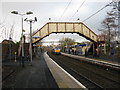
7
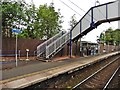
Footbridge at Drumchapel railway station
Image: © Roger Cornfoot
Taken: 19 Jun 2018
0.05 miles
8
Drumchapel railway station
Viewed from a Glasgow bound train.
Image: © Thomas Nugent
Taken: 5 Apr 2011
0.06 miles
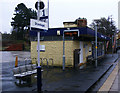
9
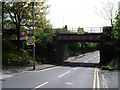
Railway bridge at Drumchapel Station
With a sign for the station in the shot also.
Image: © Stephen Sweeney
Taken: 6 May 2008
0.06 miles
10
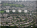
Blairdardie from the air
The four towerblocks on Keal Crescent by the A82 Great Western Road are prominent, with Knightswood golf course beyond.
Image: © Thomas Nugent
Taken: 6 Sep 2019
0.06 miles