IMAGES TAKEN NEAR TO
Kaystone Road, GLASGOW, G15 6QN
Introduction
This page details the photographs taken nearby to Kaystone Road, G15 6QN by members of the Geograph project.
The Geograph project started in 2005 with the aim of publishing, organising and preserving representative images for every square kilometre of Great Britain, Ireland and the Isle of Man.

There are currently over 7.5m images from over14,400 individuals and you can help contribute to the project by visiting https://www.geograph.org.uk
Image Map
Images are licensed for reuse under creativecommons.org/licenses/by-sa/2.0
Notes
- Clicking on the map will re-center to the selected point.
- The higher the marker number, the further away the image location is from the centre of the postcode.
Image Listing (55 Images Found)
Images are licensed for reuse under creativecommons.org/licenses/by-sa/2.0
Image
Details
Distance
1
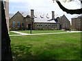
Former Drumchapel School for the Mentally Handicapped
On Garscadden Road. Became the Thomas Fortune Centre for adults with learning difficulties in 1990, and this facility has since moved away from the building also.
Image: © Stephen Sweeney
Taken: 6 May 2008
0.07 miles
2
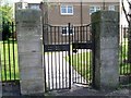
Former school gates on Garscadden Road
This was the Drumchapel School for the Mentally Handicapped.
Image: © Stephen Sweeney
Taken: 6 May 2008
0.07 miles
3
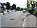
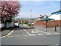
Garscadden Road, Old Drumchapel
Looking south from near the railway bridge.
Image: © Stephen Sweeney
Taken: 6 May 2008
0.11 miles
4
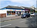
Gowanlea Nursery
Private nursery on the corner of Garscadden Road and Gowanlea Road.
Image: © Stephen Sweeney
Taken: 6 May 2008
0.11 miles
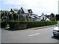
5
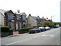
Housing on Garscadden Road
Just to the south of the former Drumchapel School for the Mentally Handicapped.
Image: © Stephen Sweeney
Taken: 6 May 2008
0.11 miles
6
Keal Crescent tower blocks at Knightswood
The Great Western Road [A82] runs across the front of the four blocks. In the foreground, housing at Old Drumchapel.
Image: © M J Richardson
Taken: 20 Jun 2015
0.11 miles
8
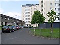
Keal Crescent, Blairdardie
Quiet residential area in the west of Glasgow.
Image: © Stephen Sweeney
Taken: 25 May 2008
0.14 miles
9
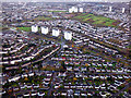
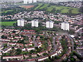
Drumchapel from the air
The towerblocks are beside the A82 Great Western Road.
Image: © Thomas Nugent
Taken: 17 Nov 2017
0.14 miles
10
Old Drumchapel housing
On Garscadden Road.
Image: © Stephen Sweeney
Taken: 6 May 2008
0.14 miles