IMAGES TAKEN NEAR TO
Howard Street, GLASGOW, G1 4AZ
Introduction
This page details the photographs taken nearby to Howard Street, G1 4AZ by members of the Geograph project.
The Geograph project started in 2005 with the aim of publishing, organising and preserving representative images for every square kilometre of Great Britain, Ireland and the Isle of Man.

There are currently over 7.5m images from over14,400 individuals and you can help contribute to the project by visiting https://www.geograph.org.uk
Image Map
Images are licensed for reuse under creativecommons.org/licenses/by-sa/2.0
Notes
- Clicking on the map will re-center to the selected point.
- The higher the marker number, the further away the image location is from the centre of the postcode.
Image Listing (2246 Images Found)
Images are licensed for reuse under creativecommons.org/licenses/by-sa/2.0
Image
Details
Distance
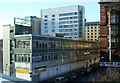
1
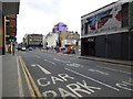
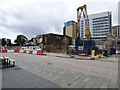
Demolition site on Howard Street
The former Aer Lingus building and supermarket has been demolished as part of a wider development of the Customhouse building on Clyde Street.
See the scene in 2013 Image
Image: © Thomas Nugent
Taken: 18 Jun 2018
0.00 miles
2
Demolition site on Howard Street
The former Aer Lingus building and supermarket has been demolished as part of a wider development of the Customhouse building on Clyde Street.
See the scene in 2013 Image
Image: © Thomas Nugent
Taken: 18 Jun 2018
0.00 miles
3

Demolition site on Howard Street
The former Aer Lingus building and supermarket has been demolished as part of a wider development of the Customhouse building on Clyde Street.
See the scene in 2013 Image
Image: © Thomas Nugent
Taken: 18 Jun 2018
0.00 miles
4
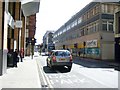
Howard Street, Glasgow
Looking east from Jamaica Street.
Image: © Stephen Sweeney
Taken: 5 May 2008
0.01 miles
5
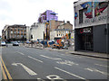
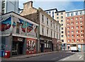
Red Sandstone Building, Glasgow
On the corner of Howard St. and St. Enoch Square.
Image: © wfmillar
Taken: 22 Jul 2011
0.02 miles
7
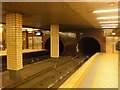
St Enoch station, Glasgow Subway
The Inner Circle line is on the right with trains approaching from Bridge Street south of the River Clyde.
Image: © Jim Barton
Taken: 19 Oct 2012
0.02 miles
8
Demolition site on Howard Street
The former Clyde House building has been demolished as part of a wider development of the Customhouse building on Clyde Street (between the two yellow machines).
See the scene in 2013 Image
Image: © Thomas Nugent
Taken: 18 Jun 2018
0.03 miles
9
St Enoch Square
One of the buildings on the west side of the square.
Image: © Thomas Nugent
Taken: 5 Nov 2011
0.03 miles
10
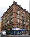
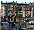
St Enoch Square
The not so grand building on Howard Street on the south side of the square. The supermarket on the ground floor closed fairly recently.
Image: © Thomas Nugent
Taken: 5 Nov 2011
0.03 miles