IMAGES TAKEN NEAR TO
Dumbarton Road, GLASGOW, G14 9UP
Introduction
This page details the photographs taken nearby to Dumbarton Road, G14 9UP by members of the Geograph project.
The Geograph project started in 2005 with the aim of publishing, organising and preserving representative images for every square kilometre of Great Britain, Ireland and the Isle of Man.

There are currently over 7.5m images from over14,400 individuals and you can help contribute to the project by visiting https://www.geograph.org.uk
Image Map
Images are licensed for reuse under creativecommons.org/licenses/by-sa/2.0
Notes
- Clicking on the map will re-center to the selected point.
- The higher the marker number, the further away the image location is from the centre of the postcode.
Image Listing (127 Images Found)
Images are licensed for reuse under creativecommons.org/licenses/by-sa/2.0
Image
Details
Distance
1
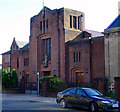
St Paul The Apostle RC Church on Dumbarton Road
At Edzell Street, in Whiteinch. Category B Listed http://portal.historicenvironment.scot/designation/LB48412 due to stained glass by Gabriel Loire.
Image: © Thomas Nugent
Taken: 25 Sep 2010
0.03 miles
2
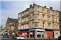
Corner of Dumbarton Road & Haldane Street, Glasgow
Image: © Leslie Barrie
Taken: 2 May 2014
0.03 miles
3
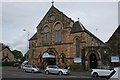
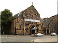
Former Gordon Park Church, Whiteinch
Built as the United Free Church in 1877, it later became the Church of Scotland, but closed in 1981. It then became a furniture storeroom and then a bathroom showroom. It is now the home of the Victoria Park Kindergarten.
Image: © Richard Sutcliffe
Taken: 23 Sep 2016
0.04 miles
4
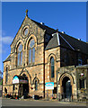
Converted church
On Dumbarton Road, Whiteinch. Now a nursery and Kindergarten.
Image: © Thomas Nugent
Taken: 25 Sep 2010
0.04 miles
5
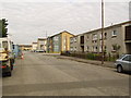
Whiteinch
Residential area surrounding Northinch Street.
Image: © Stephen Sweeney
Taken: 9 Aug 2007
0.04 miles
6
Nova Bathrooms, Whiteinch
A former church, now a bathroom showroom. How odd....!
Image: © Stephen Sweeney
Taken: 9 Aug 2007
0.04 miles
7
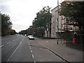
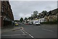
Dumbarton Road
A residential street, now replaced by Victoria Park South as a traffic artery.
Image: © Richard Webb
Taken: 26 Sep 2009
0.07 miles
8
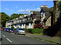
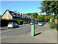
Victoria Park Street
Cottages line both sides of this street. Victoria Park is in the distance, behind the trees.
Image: © Thomas Nugent
Taken: 25 Sep 2010
0.08 miles
9
Victoria Park Street
As the name suggests, it leads to Victoria Park.
Image: © Thomas Nugent
Taken: 25 Sep 2010
0.08 miles
10
Dumbarton Road
Seen from the junction with Edzell Street.
Image: © Richard Sutcliffe
Taken: 23 Sep 2016
0.09 miles