IMAGES TAKEN NEAR TO
Dumbarton Road, GLASGOW, G14 9QD
Introduction
This page details the photographs taken nearby to Dumbarton Road, G14 9QD by members of the Geograph project.
The Geograph project started in 2005 with the aim of publishing, organising and preserving representative images for every square kilometre of Great Britain, Ireland and the Isle of Man.

There are currently over 7.5m images from over14,400 individuals and you can help contribute to the project by visiting https://www.geograph.org.uk
Image Map
Images are licensed for reuse under creativecommons.org/licenses/by-sa/2.0
Notes
- Clicking on the map will re-center to the selected point.
- The higher the marker number, the further away the image location is from the centre of the postcode.
Image Listing (131 Images Found)
Images are licensed for reuse under creativecommons.org/licenses/by-sa/2.0
Image
Details
Distance
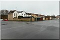
1
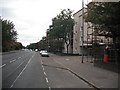
Dumbarton Road
A residential street, now replaced by Victoria Park South as a traffic artery.
Image: © Richard Webb
Taken: 26 Sep 2009
0.02 miles
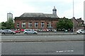
2
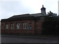
Whiteinch Library
A wonderful resource centre, with lots of fascinating historical records.
Image: © Barbara Carr
Taken: 22 Apr 2013
0.06 miles
3
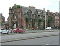
Former Whiteinch Burgh Hall
Category B listed building, dating from 1894 http://portal.historicenvironment.scot/designation/LB50283. Parts of the building were once a police station and a fire station. Most of the building has been unoccupied for several years and it is in the Buildings at Risk Register https://www.buildingsatrisk.org.uk/details/904642. It certainly appears to have deteriorated since photographed in December 2019 Image, with much vegetation growth evident.
Image: © Richard Sutcliffe
Taken: 12 Jul 2021
0.07 miles
4
Former Whiteinch Burgh Hall
Category B listed building, dating from 1894 http://portal.historicenvironment.scot/designation/LB50283. Parts of the building were once a police station and a fire station. Most of the building has been unoccupied for several years and it is in the Buildings at Risk Register https://www.buildingsatrisk.org.uk/details/904642.
Image: © Richard Sutcliffe
Taken: 20 Dec 2019
0.07 miles
5
Junction of Northinch Street and Squire Street
The garages (facing onto Northinch Street) are at the rear of Summerfield Cottages.
Image: © Richard Sutcliffe
Taken: 10 Feb 2025
0.07 miles
6
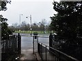
Towards Victoria Park
Looking across the A814 to Victoria Park from Whiteinch Library.
Image: © Barbara Carr
Taken: 22 Apr 2013
0.07 miles
7
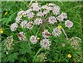
Beetles on an Umbellifera
Numerous common red soldier beetles, Rhagonycha fulva, on the head of hogweed, Heracleum spondyllum. The beetles were common in an area of uncut grassland within Victoria Park.
Image: © Richard Sutcliffe
Taken: 12 Jul 2021
0.08 miles
8
Whiteinch Library
The library is currently under threat of permanent closure. The library is owned by Glasgow City Council, but run by Glasgow Life on their behalf. Many posters and leaflets have been attached to the railing outside protesting about the proposal.
Seen from across the A814 from Victoria Park.
Image: © Richard Sutcliffe
Taken: 12 Jul 2021
0.08 miles
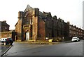
9
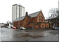
Former Whiteinch Jordanvale Parish Church and hall
Category B listed https://portal.historicenvironment.scot/apex/f?p=1505:300:::::VIEWTYPE,VIEWREF:designation,LB32282 former church, built in 1911 by P Macgregor Chalmers as Whiteinch Church to replace an earlier building dating from 1876/77, which had structural problems. The church was renamed Whiteinch Jordanvale Church at the union with the United Free Church in 1929. In 1981 the church united with Gordon Park Church, but continued to be used. A further union with Scotstoun Church in 1992 resulted in its closure. The building was sold and converted to housing.
The tower block behind is on Curle Street.
Image: © Richard Sutcliffe
Taken: 10 Feb 2025
0.09 miles
10
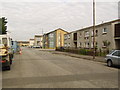
Whiteinch
Residential area surrounding Northinch Street.
Image: © Stephen Sweeney
Taken: 9 Aug 2007
0.09 miles