IMAGES TAKEN NEAR TO
Victoria Park Drive South, GLASGOW, G14 9NX
Introduction
This page details the photographs taken nearby to Victoria Park Drive South, G14 9NX by members of the Geograph project.
The Geograph project started in 2005 with the aim of publishing, organising and preserving representative images for every square kilometre of Great Britain, Ireland and the Isle of Man.

There are currently over 7.5m images from over14,400 individuals and you can help contribute to the project by visiting https://www.geograph.org.uk
Image Map
Images are licensed for reuse under creativecommons.org/licenses/by-sa/2.0
Notes
- Clicking on the map will re-center to the selected point.
- The higher the marker number, the further away the image location is from the centre of the postcode.
Image Listing (83 Images Found)
Images are licensed for reuse under creativecommons.org/licenses/by-sa/2.0
Image
Details
Distance
1

Whiteinch Victoria Park railway station (site), Glasgow
Opened in 1897 by the North British Railway as the terminus of a short branch line from Jordanhill, this site had previously been for goods only. It closed to passengers in 1951 and completely in 1967.
View south west towards the buffers. The path is partially on the site of the platform with goods sidings having been further to the right. Little trace now remains and the site is now a public park.
Image: © Nigel Thompson
Taken: 21 Feb 2019
0.02 miles
2
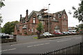
Whiteinch Homes, Westland Drive
Like an English almshouse, this building was originally built to house retired employees of the Allan shipping line.
Image: © Richard Webb
Taken: 26 Sep 2009
0.07 miles
3
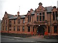
21 Westland Drive
A Category B listed building http://portal.historicenvironment.scot/designation/LB32285. A former late 19th century orphanage (Westercraigs Home For Girls) designed by architect Stewart Henbest Capper.
Image: © Richard Sutcliffe
Taken: 23 Sep 2016
0.07 miles
4
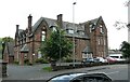
21 Westland Drive
A Category B listed building http://portal.historicenvironment.scot/designation/LB32285. A former late 19th century orphanage (Westercraigs Home For Girls) designed by architect Stewart Henbest Capper.
Image: © Richard Sutcliffe
Taken: 12 Jul 2021
0.08 miles


7

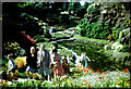
Through the rocks at the Fossil Grove rock garden
From the web: "The area near the Fossil Grove is one of the finest rock gardens in Europe. While many of the plants are not strictly of the rock garden variety, the area is hauntingly beautiful in summer."
Image: © Darrin Antrobus
Taken: 1 May 2007
0.09 miles
8
Small Pond in Victoria Park
This pond is in a rockery type area close to the Fossil Grove in the park. In the 196o's it was full of lovely flowers and plants and was very popular with the locals.
Image: © Nigel Mykura
Taken: 11 Aug 1963
0.09 miles
9
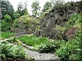
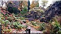
Quarry Knowe Rock Garden
The garden is within the former quarry immediately behind Fossil Grove, and has been a feature of Victoria Park since the late 1800s. The pond no longer retains much water and is more or less full of emergent vegetation.
Image: © Richard Sutcliffe
Taken: 12 Jul 2021
0.09 miles