IMAGES TAKEN NEAR TO
Lennox Avenue, GLASGOW, G14 9HG
Introduction
This page details the photographs taken nearby to Lennox Avenue, G14 9HG by members of the Geograph project.
The Geograph project started in 2005 with the aim of publishing, organising and preserving representative images for every square kilometre of Great Britain, Ireland and the Isle of Man.

There are currently over 7.5m images from over14,400 individuals and you can help contribute to the project by visiting https://www.geograph.org.uk
Image Map
Images are licensed for reuse under creativecommons.org/licenses/by-sa/2.0
Notes
- Clicking on the map will re-center to the selected point.
- The higher the marker number, the further away the image location is from the centre of the postcode.
Image Listing (78 Images Found)
Images are licensed for reuse under creativecommons.org/licenses/by-sa/2.0
Image
Details
Distance
1
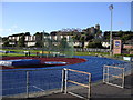
Scotstoun Track
Used for national and international athletics meets. Part of the Scotstoun leisure centre facilities.
Image: © Chris Upson
Taken: 1 Sep 2005
0.05 miles
2
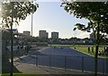
Scotstoun Track
Thursday night sessions at Scotstoun track
Image: © Chris Upson
Taken: 1 Sep 2005
0.05 miles
3
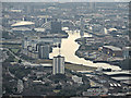
Glasgow and the Clyde from the air
Scotstoun is in the foreground. The landmark structures at the former docklands are from left to right, the Hydro Arena, the Clyde Auditorium, the Clyde Arc bridge, BBC Scotland HQ, Glasgow Science Centre and tower, Glasgow Imax cinema.
The M74 Northern Extension can be seen curving in and out at the top right.
Image: © Thomas Nugent
Taken: 14 Sep 2015
0.05 miles
4

Whiteinch Victoria Park railway station (site), Glasgow
Opened in 1897 by the North British Railway as the terminus of a short branch line from Jordanhill, this site had previously been for goods only. It closed to passengers in 1951 and completely in 1967.
View south west towards the buffers. The path is partially on the site of the platform with goods sidings having been further to the right. Little trace now remains and the site is now a public park.
Image: © Nigel Thompson
Taken: 21 Feb 2019
0.06 miles
5
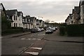
Norse Road
Seen from Duncan Avenue.
Image: © Richard Sutcliffe
Taken: 10 Feb 2017
0.10 miles
6
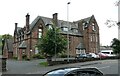
21 Westland Drive
A Category B listed building http://portal.historicenvironment.scot/designation/LB32285. A former late 19th century orphanage (Westercraigs Home For Girls) designed by architect Stewart Henbest Capper.
Image: © Richard Sutcliffe
Taken: 12 Jul 2021
0.11 miles
7
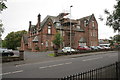
21 Westland Drive
A Category B listed building http://portal.historicenvironment.scot/designation/LB32285. A former late 19th century orphanage (Westercraigs Home For Girls) designed by architect Stewart Henbest Capper.
Image: © Richard Sutcliffe
Taken: 23 Sep 2016
0.11 miles
8
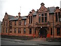
Whiteinch Homes, Westland Drive
Like an English almshouse, this building was originally built to house retired employees of the Allan shipping line.
Image: © Richard Webb
Taken: 26 Sep 2009
0.11 miles
9
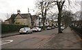
The end of Lennox Avenue on a frosty December morning
Image: © Alpin Stewart
Taken: 27 Dec 2017
0.12 miles
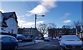
10
Duncan Avenue
The houses face Scotstoun Primary School.
Image: © Richard Sutcliffe
Taken: 10 Feb 2017
0.12 miles