IMAGES TAKEN NEAR TO
Larchfield Avenue, GLASGOW, G14 9BZ
Introduction
This page details the photographs taken nearby to Larchfield Avenue, G14 9BZ by members of the Geograph project.
The Geograph project started in 2005 with the aim of publishing, organising and preserving representative images for every square kilometre of Great Britain, Ireland and the Isle of Man.

There are currently over 7.5m images from over14,400 individuals and you can help contribute to the project by visiting https://www.geograph.org.uk
Image Map
Images are licensed for reuse under creativecommons.org/licenses/by-sa/2.0
Notes
- Clicking on the map will re-center to the selected point.
- The higher the marker number, the further away the image location is from the centre of the postcode.
Image Listing (13 Images Found)
Images are licensed for reuse under creativecommons.org/licenses/by-sa/2.0
Image
Details
Distance

2
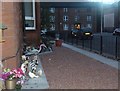
Bringing 'wildlife' into town, Dumbarton Road
Image: © Alan Reid
Taken: 9 Sep 2013
0.06 miles
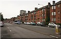
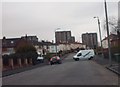
4
Raploch Avenue
At the junction with Dumbarton Road.
Image: © Richard Sutcliffe
Taken: 14 Jul 2016
0.07 miles
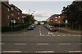
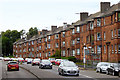
5
A814 Dumbarton Road
Red sandstone tenements.
Image: © Richard Sutcliffe
Taken: 14 Jul 2016
0.12 miles
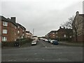
6
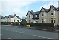
Gleneagles Cottages, Scotstoun
Residential housing on Dumbarton road.
Image: © Barbara Carr
Taken: 18 Apr 2013
0.14 miles
8
Danes Drive
Looking towards the flats at Kingsway Court.
Image: © Lynn M Reid
Taken: 26 Mar 2008
0.17 miles
9
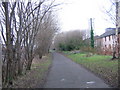
Cycleway at Scotstoun
The Glasgow to Loch Lomond cycleway follows the former Caledonian Railway line through Scotstoun. Here it is running on embankment behind the tenements of Earl Street and passing an ivy-wrapped reminder of just how many pairs of wires were required for telephone lines in the days before multi-core screened cables.
In the distance the cycleway deviates to the right to follow the Rothesay Dock branch as the original riverside line has been cut by new housing developments.
Image: © A-M-Jervis
Taken: 15 Dec 2007
0.19 miles
10
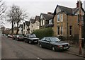
Howe Cottages, Earlbank Avenue
A row of yellow sandstone properties on Earlbank Avenue.
The nearest car appears to have been sitting in its present position for some time, as it has two flat tyres.
Image: © Richard Sutcliffe
Taken: 10 Feb 2017
0.20 miles