IMAGES TAKEN NEAR TO
Queen Victoria Drive, GLASGOW, G14 9BL
Introduction
This page details the photographs taken nearby to Queen Victoria Drive, G14 9BL by members of the Geograph project.
The Geograph project started in 2005 with the aim of publishing, organising and preserving representative images for every square kilometre of Great Britain, Ireland and the Isle of Man.

There are currently over 7.5m images from over14,400 individuals and you can help contribute to the project by visiting https://www.geograph.org.uk
Image Map
Images are licensed for reuse under creativecommons.org/licenses/by-sa/2.0
Notes
- Clicking on the map will re-center to the selected point.
- The higher the marker number, the further away the image location is from the centre of the postcode.
Image Listing (39 Images Found)
Images are licensed for reuse under creativecommons.org/licenses/by-sa/2.0
Image
Details
Distance
1
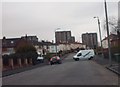
Danes Drive
Looking towards the flats at Kingsway Court.
Image: © Lynn M Reid
Taken: 26 Mar 2008
0.08 miles
2
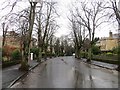
Southbrae Drive
Tree lined street after heavy rain.
Image: © Richard Webb
Taken: 19 Jan 2014
0.15 miles
3
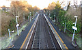
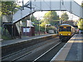
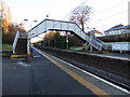
Scotstounhill railway station
Looking towards Jordanhill from the footbridge.
Image: © Thomas Nugent
Taken: 31 Dec 2019
0.17 miles
4
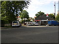
Scotstounhill railway station
From across Kingsway.
Image: © Stephen Sweeney
Taken: 9 Aug 2007
0.18 miles
5
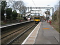
Glasgow-bound at Scotstounhill
A 3-car electric train calls at Scotstounhill Station (Platform 1) on its way to Motherwell
Image: © Raymond Okonski
Taken: 19 Oct 2007
0.18 miles
6
Eastbound platform of Scotstounhill Station
For trains to Glasgow. Taken from a Clydebank-bound train.
Image: © Stephen Sweeney
Taken: 16 Feb 2008
0.18 miles
7
Scotstounhill Railway Station
The station between Jordanhill and Garscadden on the lines from Glasgow to Balloch and Helensburgh.
Image: © G Laird
Taken: 20 Mar 2010
0.18 miles
9
Scotstounhill railway station
The station footbridge.
Image: © Thomas Nugent
Taken: 31 Dec 2019
0.19 miles
10
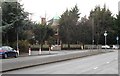
Tower Dene
A Category C listed house http://portal.historicenvironment.scot/designation/LB32299 at the corner of Southbrae Drive and Anniesland Road, dating from 1900.
Image: © Richard Sutcliffe
Taken: 19 Dec 2019
0.19 miles