IMAGES TAKEN NEAR TO
Gosford Lane, GLASGOW, G14 0XG
Introduction
This page details the photographs taken nearby to Gosford Lane, G14 0XG by members of the Geograph project.
The Geograph project started in 2005 with the aim of publishing, organising and preserving representative images for every square kilometre of Great Britain, Ireland and the Isle of Man.

There are currently over 7.5m images from over14,400 individuals and you can help contribute to the project by visiting https://www.geograph.org.uk
Image Map
Images are licensed for reuse under creativecommons.org/licenses/by-sa/2.0
Notes
- Clicking on the map will re-center to the selected point.
- The higher the marker number, the further away the image location is from the centre of the postcode.
Image Listing (50 Images Found)
Images are licensed for reuse under creativecommons.org/licenses/by-sa/2.0
Image
Details
Distance
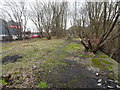
1
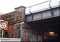
Old Railway Bridge.
Bridge, seen from Burnham Road is now part of a cyclepath.
Image: © Lynn M Reid
Taken: 26 Mar 2008
0.06 miles
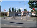
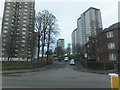
2
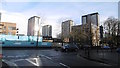
Dumbarton Road
Exit from Ardsloy Place.
Image: © Richard Webb
Taken: 4 Jan 2016
0.07 miles
3
Disused Railway Bridge over Dumbarton Road
Image: © David Dixon
Taken: 2 Aug 2019
0.08 miles
4
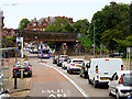
Dumbarton Road passes under a dismantled railway
A walkway now uses this rather massive bridge
Image: © Alan Reid
Taken: 9 Sep 2013
0.08 miles
5
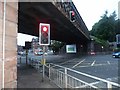
Scotstoun West railway station (site), Glasgow
Opened in 1896 as "Scotstoun" by the Lanarkshire and Dumbartonshire Railway, part of the Caledonian Railway, on the line from Partick to Dumbarton. The name was changed to Scotstoun West in 1900. The station closed in 1964.
View north west towards Yoker Ferry and Dumbarton. Both the platform on the viaduct and the former entrance down below at street level were both extant when this image was taken. A bridleway is adjacent to the station site.
Image: © Nigel Thompson
Taken: 21 Feb 2019
0.08 miles
6
Shops at the bottom of Kingsway
In Scotstoun.
Image: © Stephen Sweeney
Taken: 27 Jul 2008
0.09 miles
8
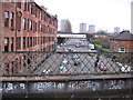
Burnham Road, Scotstoun
In the foreground is the parapet of the Caledonian Railway's Riverside line from Glasgow Central Low Level to Dumbarton, here crossing Burnham Road just west of the former Scotstoun West station, opened in 1896 and closed in 1964. In the middle distance, where Burnham Road meets Dumbarton Road and continues on as Anniesland Road towards the tower blocks at Scotstounhill, the long bridge diagonally over the crossroads was built in 1907 to take a goods branch line to Rothesay Dock, an expensive line to construct as it involved a number of other large bridges under and over roads and also under the Riverside line itself at Yoker Ferry station. It had to take an "inland" route as the land between the Riverside line and the river was fully occupied by shipyards and other engineering works. The route of the Riverside line has been obliterated by new housing development further west and the Glasgow to Loch Lomond cycleway, which follows the old railway from Partick, is deviated via the Rothesay Dock branch as far as Yoker.
Image: © A-M-Jervis
Taken: 15 Dec 2007
0.10 miles
9

Double rainbow from Scotstoun
View of a double rainbow from the builder's merchant.
Image: © bill
Taken: Unknown
0.12 miles
10
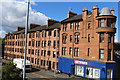
Larchfield Avenue, Scotstoun
Housing just off Dumbarton Road.
Image: © Barbara Carr
Taken: 18 Apr 2013
0.14 miles