IMAGES TAKEN NEAR TO
Ferryden Court, GLASGOW, G14 0SR
Introduction
This page details the photographs taken nearby to Ferryden Court, G14 0SR by members of the Geograph project.
The Geograph project started in 2005 with the aim of publishing, organising and preserving representative images for every square kilometre of Great Britain, Ireland and the Isle of Man.

There are currently over 7.5m images from over14,400 individuals and you can help contribute to the project by visiting https://www.geograph.org.uk
Image Map
Images are licensed for reuse under creativecommons.org/licenses/by-sa/2.0
Notes
- Clicking on the map will re-center to the selected point.
- The higher the marker number, the further away the image location is from the centre of the postcode.
Image Listing (110 Images Found)
Images are licensed for reuse under creativecommons.org/licenses/by-sa/2.0
Image
Details
Distance
1
Old railway line
Runs parallel to South Street, now part of the National Cycle Network, Route 7.
Image: © Thomas Nugent
Taken: 25 Sep 2010
0.04 miles
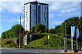
2
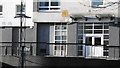
64 Curle Street
Entrance to a tower block.
Image: © Richard Webb
Taken: 4 Jan 2016
0.05 miles
3
64 Curle Street
Block of flats, Whiteinch
Image: © Richard Webb
Taken: 4 Jan 2016
0.05 miles
4
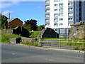
Whiteinch Riverside railway station (site), Glasgow
Opened in 1896 as "Whiteinch" by the Lanarkshire and Dumbartonshire Railway, effectively part of the Caledonian Railway, on the line from Partick to Dumbarton, "Riverside" was added to the name in 1953. The station closed in 1964.
View north west towards Scotstoun East and Dumbarton. The line was on a viaduct here parallel to South Street, with the building being above the bridge over Ferryden Street, on the right of this image. All have been swept away and replaced by housing. However the viaduct was extant beyond the station site (marked by the trees in the distance) and in use as a public footpath, when this image was taken.
Image: © Nigel Thompson
Taken: 29 Apr 2019
0.05 miles
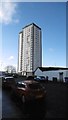
5
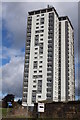
Curle Street Tower Block, Whiteinch, Glasgow
Image: © Leslie Barrie
Taken: 23 Aug 2014
0.06 miles
6
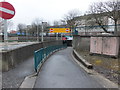
Pedestrian entrance to Clyde Tunnel
No cyclists! (My daughter and I misread the signs, and thought that this entrance was completely closed - we had quite a walk to find the next admission point.)
Image: © Barbara Carr
Taken: 22 Apr 2013
0.06 miles
7
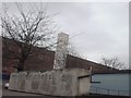
Whiteinch Cross
This can be quite a nice feature when its working.
Image: © Lynn M Reid
Taken: 26 Mar 2008
0.06 miles
8
Old railway line
Traces of the old North British line at the corner of South Street and Farryden Street.
Image: © Thomas Nugent
Taken: 25 Sep 2010
0.06 miles
9
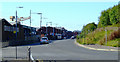
South Street
Looking West on South Street. The Clyde Tunnel passes underneath the area in the foreground.
Image: © Thomas Nugent
Taken: 25 Sep 2010
0.06 miles
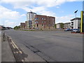
10
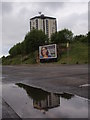
Old railway embankment with Smith Street flats behind
South Street, in the foreground, is extremely quiet on a Sunday morning. The disused railway embankment comes to an end on this corner, where South Street and Ferryden Street meet. It now boasts an advertising hoarding.
Image: © Alec MacKinnon
Taken: 25 May 2014
0.06 miles